| This article is rated List-class on Wikipedia's content assessment scale. It is of interest to the following WikiProjects: | ||||||||||||||||||||||||||||||||||
| ||||||||||||||||||||||||||||||||||


Suggestion[edit]
If tables aren't implemented (as proposed in the previous section), then the section "Listing by tributary structure" -> "Pacific Ocean" ought to be divided into (1) Columbia River, & (2) all other streams emptying directly into the sea. The present organization makes it very difficult to find the rivers/streams in the second group. -- llywrch (talk) 20:21, 2 September 2020 (UTC)
to do[edit]
- Millicoma River 9 miles, tributary of Coos River, has east and west forks, join at Allegany, Oregon: [1]
east fork, west fork; (why doesn't it appear in one of these?: [2] [3] [4])
—EncMstr 23:33, 30 October 2007 (UTC)
- I have no idea why it was overlooked, except that OGN says it is sometimes called the North Fork Coos River, although the USBGN uses the name Millicoma. Strange. Katr67 03:12, 31 October 2007 (UTC)
Collapsible sections?[edit]
As this list gets longer and more complete, is there some way to make it less unwieldy? Perhaps there is some way to make the minor tributary creeks be in collapsible sections. Other ideas are welcome. Katr67 (talk) 06:07, 5 September 2008 (UTC)
- Why unwieldy? Shouldn't a list of rivers (better named List of Streams) show all of them? Are you suggesting that major, middling, and minor be distinguished? —EncMstr (talk) 14:28, 5 September 2008 (UTC)
- Of course it should show all of them, but maybe hide the lesser ones unless the reader wants to see them. I was thinking of the creeks, especially ones that may not be notable enough to be linked, not to disrespect Finetooth's efforts to figure out the tributary structures. I trust the Johnson Creek tributaries will eventually have articles, thanks to the efforts of Finetooth and others. I guess I'm thinking in terms of the future--if we add every creek to the tributary structure, that list is going to be long! With large indents, and thus harder to navigate. Meanwhile, I'm going to try to find any stream named a "river" on GNIS that isn't in here yet and add them. Katr67 (talk) 18:33, 5 September 2008 (UTC)
- As I was adding the Alsea River tribs, I had the same thought as Katr67. Lots of these trifling streams will never have their own articles, methinks. If I keep on in this way, the list is going to become enormous. I like doing the trib structures, and I'll almost certainly do more unless I'm wrestled to the ground and told to cut it out. We might eventually end up with a complete list of all the named streams in Oregon. From doing the 40 or so miles of the Alsea, I can guarantee that a complete list will be very long indeed. I don't know what to do about it, however. I'm a neophyte when it comes to things like collapsing sections. Finetooth (talk) 21:27, 5 September 2008 (UTC)
Sources for expansion[edit]
This is a list from NOAA of flood warnings. The drop-down menus for the tributaries might give some idea which creeks might be good candidates for inclusion in the list and for articles, as they may be more notable for their "floodproneness".
A non-profit, "Protecting Natural Flows in Oregon Rivers".
Katr67 (talk) 22:34, 29 September 2008 (UTC)
State of Oregon site--"Find your watershed". Katr67 (talk) 23:12, 29 September 2008 (UTC)
I found this funny little list, but it doesn't have Oregon in it. Finding the info and adding it to the list might be a good afternoon's project for someone. Katr67 (talk) 22:49, 29 September 2008 (UTC)
Tables?[edit]
This seems like the awesome type of list to raise to featured status, but I'm pretty sure it won't get there unless we use tables. We should probably keep the current format of sections for an alphabetical listing and tributary structure. I hope I'm not jumping into this too fast, but here's a suggestion for how to build the tables. I'm using the Columbia and Willamette as examples.
| Name | Image | Description | References |
|---|---|---|---|
| Columbia River |  |
The longest river in the Pacific Northwest, the 2,000-km Columbia flows from southeastern British Columbia south through Washington and east along the Oregon-Washington border into the Pacific Ocean. | [1] |
| Willamette River |  |
Named after a Clackamas Indian village, the Willamette flows from the Cascade foothills north through the Willamette Valley into the Columbia River in Portland. | [2][3] |
Feel free to list other suggestions about the table. --Jsayre64 (talk) 02:12, 7 April 2011 (UTC)
- ^ Lang, Bill. "Columbia River". Center for Columbia River History. Retrieved April 6, 2011.
- ^ Bright, William (2004). Native American Placenames of the United States. Norman, Oklahoma: University of Oklahoma Press. p. 567. ISBN 0-8061-3576-X.
- ^ "Willamette River". Geographic Names Information System. United States Geological Survey, United States Department of the Interior. 28 November 1980. Retrieved April 6, 2011.
- I've added a lot of mostly insignificant tribs over the past three years or so to the trib structure sublist. Almost three years ago, Katr67 (Valfontis) suggested above that the lesser streams in the sublist be hidden to make it more easily navigable. Maybe the alphabetical list of the rivers only could be turned into a table like the one you are suggesting, and the non-alphabetical list with all the tribs could become a separate article with collapsing boxes. However, even eliminating the creeks from the alphabetical list leaves close to 200 rivers, by my rough count. Would a table with 200 rows be practical? Finetooth (talk) 03:38, 7 April 2011 (UTC)
- I support that idea to reduce clutter. If readers see a 200-row table as a burden, it might help to split into alphabetical sections for rivers A-C, D-F, and so on. That's pretty much the style in List of parks in Portland, Oregon, which received general support. --Jsayre64 (talk) 04:14, 7 April 2011 (UTC)
- Sounds good to me if you want to undertake it, but others might want to weigh in too. Finetooth (talk) 04:46, 7 April 2011 (UTC)
- I'm working on a collapsible items solution. No idea how long that might take, or if it is feasible.
- A table would be appropriate if, besides the stream name, it has useful highlights:
- Sounds good to me if you want to undertake it, but others might want to weigh in too. Finetooth (talk) 04:46, 7 April 2011 (UTC)
- I support that idea to reduce clutter. If readers see a 200-row table as a burden, it might help to split into alphabetical sections for rivers A-C, D-F, and so on. That's pretty much the style in List of parks in Portland, Oregon, which received general support. --Jsayre64 (talk) 04:14, 7 April 2011 (UTC)
- I've added a lot of mostly insignificant tribs over the past three years or so to the trib structure sublist. Almost three years ago, Katr67 (Valfontis) suggested above that the lesser streams in the sublist be hidden to make it more easily navigable. Maybe the alphabetical list of the rivers only could be turned into a table like the one you are suggesting, and the non-alphabetical list with all the tribs could become a separate article with collapsing boxes. However, even eliminating the creeks from the alphabetical list leaves close to 200 rivers, by my rough count. Would a table with 200 rows be practical? Finetooth (talk) 03:38, 7 April 2011 (UTC)
Name photo length max flow min flow drop dams color sub/urban description references Columbia River 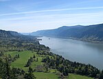
2,000 kilometres (1,200 mi)[1] 750000 cfs[1] 32 cfs[1] 8,000 metres (26,000 ft)[1] 121[1] mostly brown 2.17%[1] The longest river in the Pacific Northwest, from southeastern British Columbia south through Washington and east along the Oregon-Washington border into the Pacific Ocean. [2] Willamette River 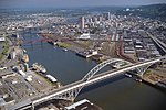
200 kilometres (120 mi)[1] 75000 cfs[1] 8 cfs[1] 2,000 metres (6,600 ft)[1] 0.5[1] mostly blue 11.7%[1] Named after a Clackamas Indian village, the Willamette flows from the Cascade foothills north through the Willamette Valley into the Columbia River in Portland. [3][4]
- ^ a b c d e f g h i j k l Made up number for illustrative purposes
- ^ Lang, Bill. "Columbia River". Center for Columbia River History. Retrieved April 6, 2011.
- ^ Bright, William (2004). Native American Placenames of the United States. Norman, Oklahoma: University of Oklahoma Press. p. 567. ISBN 0-8061-3576-X.
- ^ "Willamette River". Geographic Names Information System. United States Geological Survey, United States Department of the Interior. 28 November 1980. Retrieved April 6, 2011.
Another option is to copy the table format in List of longest streams of Oregon, a featured list. Or maybe we could combine your suggested format with that one, so long as the table doesn't become too wide. --Jsayre64 (talk) 00:37, 8 April 2011 (UTC)
- I doubt it's possible to collapse sections of tables. This was, if I understood correctly, not what you had in mind, EncMstr, and this was a problematic result. Maybe we could ask at WP:VPT? --Jsayre64 (talk) 15:12, 17 April 2011 (UTC)
- It is indeed time to ask as VPT; I've asked at Template talk:Collapsible bulletlist and Template talk:Collapsible list. At the former, someone identified the flaw of using that template and said they would look into it. I haven't seen anything more yet. If you don't beat me to it, I'll ask at WP:VPT. —EncMstr (talk) 00:25, 18 April 2011 (UTC)
| Name | Photo | Length | Max. flow | Min. flow | Source | Mouth | Drop | Number of dams | Color | Sub/urban | Description | References |
|---|---|---|---|---|---|---|---|---|---|---|---|---|
| Columbia River | |
2,000 kilometres (1,200 mi) | 750000 cfs | 32 cfs | Columbia Lake, British Columbia, 50°13′00″N 115°51′00″W / 50.21667°N 115.85000°W | Pacific Ocean, 46°14′39″N 124°03′29″W / 46.24417°N 124.05806°W | 8,000 metres (26,000 ft) | 121 | Mostly brown | 2.17% | The longest river in the Pacific Northwest, from southeastern British Columbia south through Washington and east along the Oregon-Washington border into the Pacific Ocean. | [1][2][3] |
| Willamette River | |
200 kilometres (120 mi) | 75000 cfs | 8 cfs | Near Eugene, 44°01′23″N 123°01′25″W / 44.02306°N 123.02361°W | Near Portland, 45°39′10″N 122°45′53″W / 45.65278°N 122.76472°W | 2,000 metres (6,600 ft) | 0.5 | Mostly blue | 11.7% | Named after a Clackamas Indian village, the Willamette flows from the Cascade foothills north through the Willamette Valley into the Columbia River in Portland. | [4][5] |
- ^ "Columbia Lake". Natural Resources Canada. Retrieved January 31, 2011.
- ^ "Columbia River". Geographic Names Information System. United States Geological Survey. November 28, 1980. Retrieved August 5, 2010.
- ^ Lang, Bill. "Columbia River". Center for Columbia River History. Retrieved April 6, 2011.
- ^ "Willamette River". Geographic Names Information System (GNIS). United States Geological Survey. November 28, 1980. Retrieved August 6, 2010.
- ^ Bright, William (2004). Native American Placenames of the United States. Norman, Oklahoma: University of Oklahoma Press. p. 567. ISBN 0-8061-3576-X.
--Jsayre64 (talk) 16:11, 18 April 2011 (UTC)
- According to what I've heard so far at VPT, this type of table can't really be collapsed; only this. So I'd say we have a section in the list with the above format for the longer/larger rivers, and a separate section with the collapsible tables for the tributary structures of those rivers. Besides, it's unlikely that there would be enough information available to use the above format for all the tribs. Does this seem reasonable? Jsayre64 (talk) 22:53, 18 April 2011 (UTC)
- Below is an example of how we can format the tributary structures, from what I heard at VPT. It's a pretty nasty code, but if we can figure it out I think it's the best option for the tributary listings.
| Header | |||||
|---|---|---|---|---|---|
| Cell 1 | Cell 2 | ||||
| |||||
| |||||
| Header | ||||||
|---|---|---|---|---|---|---|
|
Cell heading
| ||||||
|
Cell heading
|
| Rivers and stuff | |
|---|---|
| By some grouping | By some other grouping |
|
* Top level
* Top Level :* Level 2
|
* Top level
* Top Level :* Level 2
|
--Jsayre64 (talk) 23:05, 19 April 2011 (UTC)
- That is certainly an option. The grunginess of that approach can be moved into templates, if it isn't already somewhere. I still am looking for a Javascript-based approach which will have several advantages, not the least of which is that one control can expand all minor tributaries, I think an important feature. —EncMstr (talk) 23:34, 19 April 2011 (UTC)
Here's an example of what can be set up with the new templates:
- Columbia River
- Skipanon River
- Lewis and Clark River
- Youngs River
- Klaskanine River
- Wallooskee River
- John Day River (northwestern Oregon)
--Jsayre64 (talk) 02:55, 20 April 2011 (UTC)
- But now we have to decide exactly which river or creek listings should be formatted into tables and which should be listed in the collapsible section. My ideas are that we could use tables for those called "rivers" (not creeks), or for those that are at least a certain length, or maybe for those that are more directly related to the Willamette, Columbia, John Day, Snake, etc. as tributaries. Any other suggestions, or which one of these would work best? Jsayre64 (talk) 16:25, 16 May 2011 (UTC)
Hi Jsayre, looks like you're doing some excellent work exploring the options, without a lot of input! Having worked on some pretty complicated, structured articles myself, I sympathize.
In general, I like the nested/collapsible bullets you show above, and I like the collapsible table cell feature as well. I guess I have two general suggestions for you, to move this forward:
(1) I think it's easier for somebody new to this discussion, rather than reading and thinking through a lot of detailed description, to simply look at an example. So, I would encourage you to be bold and edit some of the content of this page in a way that you think is an improvement. Even if it's just a couple of rivers. If you're worried about an inconsistent article, you could even make the edit, and then revert it, so that you have a past revision to point to. Or you could put an actual example of what you'd like to do here on the talk page.
(2) I wouldn't get too hung up on the question of what is the best way to break up "big" and "small" rivers. Names of "river" or "creek" can be pretty arbitrary and inconsistent, and length is often wildly different from volume, or economic significance, or scenic beauty. Ultimately, the most important thing is to have a list that helps the reader absorb a lot of detailed information, and/or drill down to the info they most need; I trust your judgment on a case-by-case basis a lot more than I'd trust any specific "rule."
Hope this helps, and I'll try to check back soon -- I don't play enough tennis as it is ;) -Pete (talk) 02:14, 25 May 2011 (UTC)
- Good point about the river/creek segregation; we could simply select some of the less-known streams to be in the collapsible listings and put the rest in tables.
- On the other hand, I have in fact provided examples already of what I think this should look like. On April 18 I presented my latest proposal for what the tables should look like, as you can see above. However I have probably missed some key components and, you know, I don't really want to publish a work in progress. :-) Jsayre64 (talk) 02:47, 25 May 2011 (UTC)
- Jsayre -- yes, I see that -- but my point is that, while you've done a very nice job of illustrating the technical possibilities, it's a little hard for me (and I'd guess others) to imagine how you want to implement it. I think at this stage, it would be a lot easier to jump into the discussion if we could see a clearer example of what you have in mind -- even if incomplete, at least something that contains the actual information from the list (as opposed to "header," "cell 1," and the like). Maybe in a new talk page section? -Pete (talk) 03:15, 25 May 2011 (UTC)
- Ah, I see. Well, as a matter of fact, that bare-code approach producing such complicated tables is very confusing and may not be necessary now that we've got the templates that Bility created. I don't really see the use of it anymore. So, if we eliminate that proposal, this is what we'll do:
- decide on a precise table format
- select the streams to put into tables and format the rest with the collapsing list templates
- avoid overwhelming readers by splitting the tables into sections alphabetically (sections A-D, E-H, I-L, etc.)
- and, of course, cite everything possible
- Nice timing Pete. Two days ago I prototyped a Javascript-based solution on one of my computers where the hierarchy is divided into three levels (which feels the best to me) and is operated by three buttons at the top: "show only major streams", "show intermediate+ streams", and "show all streams". I've investigated integrating that into a page, and I believe everything is kosher. I'll give it a whirl on a subpage somewhere. —EncMstr (talk) 02:49, 25 May 2011 (UTC)
- I haven't forgotten, but got bogged down in doing the whole page, which is much more complicated than one subtree and so the whole indentation hierarchy got screwed up somehow. I'm going to write a program to do the transformation; the previous attempts have all been hand edits. Besides the snafu on that, I'm involved in Rose Festival so won't be able to work on it until Monday. —EncMstr (talk) 14:26, 12 June 2011 (UTC)
- I think we should also place some larger, scenic images on the side (after each section, perhaps, to avoid breaking the table) to illustrate the entire list. We can borrow most of these from river articles. The list would look really nice with images like this one, this one, and of course this gorgeous featured pic. I still support having a thumbnail in each table row as well. Jsayre64 (talk) 02:31, 16 June 2011 (UTC)
- I haven't forgotten, but got bogged down in doing the whole page, which is much more complicated than one subtree and so the whole indentation hierarchy got screwed up somehow. I'm going to write a program to do the transformation; the previous attempts have all been hand edits. Besides the snafu on that, I'm involved in Rose Festival so won't be able to work on it until Monday. —EncMstr (talk) 14:26, 12 June 2011 (UTC)
| Name | Photo | Length | Max. flow recorded | Min. flow recorded | Source | Mouth | Drainage area | Number of dams | Color | Sub/urban | Description | References |
|---|---|---|---|---|---|---|---|---|---|---|---|---|
| Columbia River | |
1,243 miles (2,000 km) | 1,240,000 cubic feet per second (35,000 m3/s) | 12,100 cubic feet per second (340 m3/s) | Columbia Lake, British Columbia, 50°13′00″N 115°51′00″W / 50.21667°N 115.85000°W | Pacific Ocean, 46°14′39″N 124°03′29″W / 46.24417°N 124.05806°W | 258,000 square miles (670,000 km2) | 14 | Mostly brown | 2.17% | The longest river in the Pacific Northwest, from southeastern British Columbia south through Washington and east along the Oregon-Washington border into the Pacific Ocean. | [1][2][3][4][5] |
| Willamette River | |
187 miles (301 km) | 460,000 cubic feet per second (13,000 m3/s) | 4,200 cubic feet per second (120 m3/s) | Near Eugene, 44°01′23″N 123°01′25″W / 44.02306°N 123.02361°W | Near Portland, 45°39′10″N 122°45′53″W / 45.65278°N 122.76472°W | 11,478 square miles (29,730 km2) | 15 | Mostly blue | 11.7% | Named after a Clackamas Indian village, the Willamette flows from the Cascade foothills north through the Willamette Valley into the Columbia River in Portland. | [6][7][8][9][10] |
- ^ "Columbia Lake". Natural Resources Canada. Retrieved January 31, 2011.
- ^ "Columbia River". Geographic Names Information System. United States Geological Survey. November 28, 1980. Retrieved August 5, 2010.
- ^ Lang, Bill. "Columbia River". Center for Columbia River History. Retrieved April 6, 2011.
- ^ "USGS Real-Time Water Data for USGS 14105700 Columbia River at the Dalles, OR". United States Geological Survey. Retrieved 2008-08-06.
- ^ "River Overview". Columbia River Keeper. 2000–2004. Retrieved 2008-04-01.
((cite web)): Check date values in:|date=(help) - ^ "Willamette River". Geographic Names Information System (GNIS). United States Geological Survey. November 28, 1980. Retrieved August 6, 2010.
- ^ Bright, William (2004). Native American Placenames of the United States. Norman, Oklahoma: University of Oklahoma Press. p. 567. ISBN 0-8061-3576-X.
- ^ "Physical Character". Willamette Riverkeeper. Retrieved June 14, 2011.
- ^ Robbins, William G. "Willamette River". The Oregon Encyclopedia. Portland State University. Retrieved June 4, 2010.
- ^ "Water-Data Report 2009: 14211720 Willamette River at Portland, OR" (PDF). United States Geological Survey. Retrieved June 30, 2010.
Feedback is always welcome. --Jsayre64 (talk) 02:31, 25 June 2011 (UTC)
- I hope you realize that the color and sub/urban columns are data I made up. Color was intended tongue-in-cheek to indicate that something about the character of the river should be included here. Perhaps the amount that is navigable would be a better choice. Suburban vs. urban seems like a great addition, but I haven't seen that in a source anywhere. —EncMstr (talk) 04:54, 25 June 2011 (UTC)
- If we can't find a source to support suburban vs. urban, that column must go. What exactly do you mean by "amount that is navigable"? Do you mean the number of miles/kilometers of each river that boats can navigate? The percentage of the length of the river that boats can navigate? Jsayre64 (talk) 15:23, 25 June 2011 (UTC)
- Otherwise, I think these tables will work pretty well. Should I start getting them ready in my sandbox now? I can select which streams to use if no one else wants to. Jsayre64 (talk) 15:29, 30 June 2011 (UTC)
- Alright, I've started all the work at User:Jsayre64/Sandbox/Tables idea. Any of you are more than welcome to help. I see no hurry in getting this done quickly, though, so we can take our time and someday get this list to FL status, hopefully. Jsayre64 (talk) 04:08, 10 August 2011 (UTC)
- Otherwise, I think these tables will work pretty well. Should I start getting them ready in my sandbox now? I can select which streams to use if no one else wants to. Jsayre64 (talk) 15:29, 30 June 2011 (UTC)
- If we can't find a source to support suburban vs. urban, that column must go. What exactly do you mean by "amount that is navigable"? Do you mean the number of miles/kilometers of each river that boats can navigate? The percentage of the length of the river that boats can navigate? Jsayre64 (talk) 15:23, 25 June 2011 (UTC)