The Geography Portal

Geography (from Ancient Greek γεωγραφία geōgraphía; combining gê 'Earth' and gráphō 'write') is the study of the lands, features, inhabitants, and phenomena of Earth. Geography is an all-encompassing discipline that seeks an understanding of Earth and its human and natural complexities—not merely where objects are, but also how they have changed and come to be. While geography is specific to Earth, many concepts can be applied more broadly to other celestial bodies in the field of planetary science. Geography has been called "a bridge between natural science and social science disciplines."
Origins of many of the concepts in geography can be traced to Greek Eratosthenes of Cyrene, who may have coined the term "geographia" (c. 276 BC – c. 195/194 BC). The first recorded use of the word γεωγραφία was as the title of a book by Greek scholar Claudius Ptolemy (100 – 170 AD). This work created the so-called "Ptolemaic tradition" of geography, which included "Ptolemaic cartographic theory." However, the concepts of geography (such as cartography) date back to the earliest attempts to understand the world spatially, with the earliest example of an attempted world map dating to the 9th century BCE in ancient Babylon. The history of geography as a discipline spans cultures and millennia, being independently developed by multiple groups, and cross-pollinated by trade between these groups. The core concepts of geography consistent between all approaches are a focus on space, place, time, and scale.
Today, geography is an extremely broad discipline with multiple approaches and modalities. There have been multiple attempts to organize the discipline, including the four traditions of geography, and into branches. Techniques employed can generally be broken down into quantitative and qualitative approaches, with many studies taking mixed-methods approaches. Common techniques include cartography, remote sensing, interviews, and surveying. (Full article...)
 Featured article -
-

White Deer Hole Creek is a 20.5-mile (33.0 km) tributary of the West Branch Susquehanna River in Clinton, Lycoming and Union counties in the U.S. state of Pennsylvania. A part of the Chesapeake Bay drainage basin, the White Deer Hole Creek watershed drains parts of ten townships. The creek flows east in a valley of the Ridge-and-valley Appalachians, through sandstone, limestone, and shale from the Ordovician, Silurian, and Devonian periods.
As of 2006, the creek and its 67.2-square-mile (174 km2) watershed are relatively undeveloped, with 28.4 percent of the watershed given to agriculture and 71.6 percent covered by forest, including part of Tiadaghton State Forest. The western part of White Deer Hole Creek has very high water quality and is the only major creek section in Lycoming County classified as Class A Wild Trout Waters, defined by the Pennsylvania Fish and Boat Commission as "streams which support a population of naturally produced trout of sufficient size and abundance to support a long-term and rewarding sport fishery." The rest of the creek and its major tributary (Spring Creek) are kept stocked. There are opportunities in the watershed for canoeing, hunting, and camping, and trails for hiking and horseback riding. (Full article...) -
Mount Berlin is a glacier-covered volcano in Marie Byrd Land, Antarctica, 100 kilometres (62 mi) from the Amundsen Sea. It is a roughly 20-kilometre-wide (12 mi) mountain with parasitic vents that consists of two coalesced volcanoes: Berlin proper with the 2-kilometre-wide (1.2 mi) Berlin Crater and Merrem Peak with a 2.5-by-1-kilometre-wide (1.55 mi × 0.62 mi) crater, 3.5 kilometres (2.2 mi) away from Berlin. The summit of the volcano is 3,478 metres (11,411 ft) above sea level. It has a volume of 200 cubic kilometres (48 cu mi) and rises from the West Antarctic Ice Sheet. It is part of the Marie Byrd Land Volcanic Province. Trachyte is the dominant volcanic rock and occurs in the form of lava flows and pyroclastic rocks.
The volcano began erupting during the Pliocene and was active into the late Pleistocene and the Holocene. Several tephra layers encountered in ice cores all over Antarctica – but in particular at Mount Moulton – have been linked to Mount Berlin, which is the most important source of such tephras in the region. The tephra layers were formed by explosive eruptions that generated high eruption columns. Presently, fumarolic activity occurs at Mount Berlin and forms ice towers from freezing steam. (Full article...) -
The Silesian Wars (German: Schlesische Kriege) were three wars fought in the mid-18th century between Prussia (under King Frederick the Great) and Habsburg Austria (under Empress Maria Theresa) for control of the Central European region of Silesia (now in south-western Poland). The First (1740–1742) and Second (1744–1745) Silesian Wars formed parts of the wider War of the Austrian Succession, in which Prussia was a member of a coalition seeking territorial gain at Austria's expense. The Third Silesian War (1756–1763) was a theatre of the global Seven Years' War, in which Austria in turn led a coalition of powers aiming to seize Prussian territory.
No particular event triggered the wars. Prussia cited its centuries-old dynastic claims on parts of Silesia as a casus belli, but Realpolitik and geostrategic factors also played a role in provoking the conflict. Maria Theresa's contested succession to the Habsburg monarchy under the Pragmatic Sanction of 1713 provided an opportunity for Prussia to strengthen itself relative to regional rivals such as Saxony and Bavaria. (Full article...) -
The Armero tragedy (Spanish: Tragedia de Armero [tɾaˈxeðja ðe aɾˈmeɾo]) occurred following the eruption of the Nevado del Ruiz stratovolcano in Tolima, Colombia, on November 13, 1985. The volcano's eruption after 69 years of dormancy caught nearby towns unprepared, even though volcanological organizations had warned the government to evacuate the area after they detected volcanic activity two months earlier.
As pyroclastic flows erupted from the volcano's crater, they melted the mountain's glaciers, sending four enormous lahars (volcanically induced mudflows, landslides, and debris flows) down its slopes at 50 km/h (30 mph). The lahars picked up speed in gullies and engulfed the town of Armero, killing more than 20,000 of its almost 29,000 inhabitants. Casualties in other towns, particularly Chinchiná, brought the overall death toll to 23,000. Footage and photographs of Omayra Sánchez, a young victim of the disaster, were published around the world. Other photographs of the lahars and the impact of the disaster captured attention worldwide and led to controversy over the degree to which the Colombian government was responsible for the disaster. A banner at a mass funeral in Ibagué read, "The volcano didn't kill 22,000 people. The government killed them." (Full article...) -
The Marshalsea (1373–1842) was a notorious prison in Southwark, just south of the River Thames. Although it housed a variety of prisoners—including men accused of crimes at sea and political figures charged with sedition—it became known, in particular, for its incarceration of the poorest of London's debtors. Over half of England's prisoners in the 18th century were in jail because of debt.
Run privately for profit, as were all English prisons until the 19th century, the Marshalsea looked like an Oxbridge college and functioned as an extortion racket. Debtors in the 18th century who could afford the prison fees had access to a bar, shop and restaurant, and retained the crucial privilege of being allowed out during the day, which gave them a chance to earn money for their creditors. Everyone else was crammed into one of nine small rooms with dozens of others, possibly for years for the most modest of debts, which increased as unpaid prison fees accumulated. The poorest faced starvation and, if they crossed the jailers, torture with skullcaps and thumbscrews. A parliamentary committee reported in 1729 that 300 inmates had starved to death within a three-month period, and that eight to ten were dying every 24 hours in the warmer weather. (Full article...) -
The Second Silesian War (German: Zweiter Schlesischer Krieg) was a war between Prussia and Austria that lasted from 1744 to 1745 and confirmed Prussia's control of the region of Silesia (now in south-western Poland). The war was fought mainly in Silesia, Bohemia, and Upper Saxony and formed one theatre of the wider War of the Austrian Succession. It was the second of three Silesian Wars fought between Frederick the Great's Prussia and Maria Theresa's Austria in the mid-18th century, all three of which ended in Prussian control of Silesia.
The conflict has been viewed as a continuation of the First Silesian War, which had concluded only two years before. After the Treaty of Berlin ended hostilities between Austria and Prussia in 1742, the Habsburg monarchy's fortunes improved greatly in the continuing War of the Austrian Succession. As Austria expanded its alliances with the 1743 Treaty of Worms, Prussia entered a renewed alliance with Austria's enemies in the League of Frankfurt and rejoined the war, hoping to prevent a resurgent Austria from taking back Silesia. (Full article...) -

Ireland is an island in Northern Europe in the north Atlantic Ocean. The island, of up to around 480 km (300 mi) north-south, and 275 km (171 mi) east-west, lies near the western edge of the European continental shelf, part of the Eurasian Plate. Its main geographical features include low central plains surrounded by coastal mountains. The highest peak is Carrauntoohil (Irish: Corrán Tuathail), which is 1,039 metres (3,409 ft) above sea level. The western coastline is rugged, with many islands, peninsulas, headlands and bays, while the southern and northern coasts feature a smaller number of substantial sea inlets, such as Lough Foyle and Cork Harbour; no part of the land is more than around 110 km (68 mi) from the sea. It was administratively divided into 32 counties, gathered in 4 provinces, though current arrangements, especially in Northern Ireland, differ from this model. The island is almost bisected by the River Shannon, which at 360.5 km (224 mi) with a 102.1 km (63 mi) estuary is the longest river in Ireland and flows south from County Cavan in the province of Ulster to form the boundary between Connacht and Leinster, and later Munster, and meet the Atlantic just south and west of Limerick. There are a number of sizeable lakes along Ireland's rivers, of which Lough Neagh is the largest.
Politically, the island consists of the Republic of Ireland, with jurisdiction over about five-sixths of the island, and Northern Ireland, a constituent part of the United Kingdom, with jurisdiction over the remaining sixth. Located west of the island of Great Britain, Ireland lies at approximately . It has a total area of 84,421 km2 (32,595 sq mi) and is separated from Great Britain by the Irish Sea, bounded to the north and south respectively by the North Channel and St George's Channel, and from mainland Europe by the Celtic Sea. Ireland forms the second largest landmass in the British Isles, together with Great Britain and the Isle of Man. (Full article...) -

The ACFEL ice auger showing an ice core pushed up into the core remover barrel.
Ice drilling allows scientists studying glaciers and ice sheets to gain access to what is beneath the ice, to take measurements along the interior of the ice, and to retrieve samples. Instruments can be placed in the drilled holes to record temperature, pressure, speed, direction of movement, and for other scientific research, such as neutrino detection.
Many different methods have been used since 1840, when the first scientific ice drilling expedition attempted to drill through the Unteraargletscher in the Alps. Two early methods were percussion, in which the ice is fractured and pulverized, and rotary drilling, a method often used in mineral exploration for rock drilling. In the 1940s, thermal drills began to be used; these drills melt the ice by heating the drill. Drills that use jets of hot water or steam to bore through ice soon followed. A growing interest in ice cores, used for palaeoclimatological research, led to ice coring drills being developed in the 1950s and 1960s, and there are now many different coring drills in use. For obtaining ice cores from deep holes, most investigators use cable-suspended electromechanical drills, which use an armoured cable to carry electrical power to a mechanical drill at the bottom of the borehole. (Full article...) -
Blakeney Point (designated as Blakeney National Nature Reserve) is a national nature reserve situated near to the villages of Blakeney, Morston and Cley next the Sea on the north coast of Norfolk, England. Its main feature is a 6.4 km (4.0 mi) spit of shingle and sand dunes, but the reserve also includes salt marshes, tidal mudflats and reclaimed farmland. It has been managed by the National Trust since 1912, and lies within the North Norfolk Coast Site of Special Scientific Interest, which is additionally protected through Natura 2000, Special Protection Area (SPA), International Union for Conservation of Nature (IUCN) and Ramsar listings. The reserve is part of both an Area of Outstanding Natural Beauty (AONB), and a World Biosphere Reserve. The Point has been studied for more than a century, following pioneering ecological studies by botanist Francis Wall Oliver and a bird ringing programme initiated by ornithologist Emma Turner.
The area has a long history of human occupation; ruins of a medieval monastery and "Blakeney Chapel" (probably a domestic dwelling) are buried in the marshes. The towns sheltered by the shingle spit were once important harbours, but land reclamation schemes starting in the 17th century resulted in the silting up of the river channels. The reserve is important for breeding birds, especially terns, and its location makes it a major site for migrating birds in autumn. Up to 500 seals may gather at the end of the spit, and its sand and shingle hold a number of specialised invertebrates and plants, including the edible samphire, or "sea asparagus". (Full article...) -
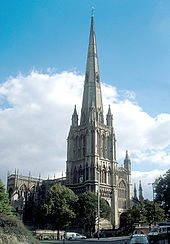
St. Mary Redcliffe from the northwest
Bristol, the largest city in South West England, has an eclectic combination of architectural styles, ranging from the medieval to 20th century brutalism and beyond. During the mid-19th century, Bristol Byzantine, an architectural style unique to the city, was developed, and several examples have survived.
Buildings from most of the architectural periods of the United Kingdom can be seen throughout Bristol. Parts of the fortified city and castle date back to the medieval era, as do some churches dating from the 12th century onwards. Outside the historical city centre there are several large Tudor mansions built for wealthy merchants. Almshouses and public houses of the same period survive, intermingled with areas of more recent development. Several Georgian-era squares were laid out for the enjoyment of the middle class. As the city grew, it merged with its surrounding villages, each with its own character and centre, often clustered around a parish church. (Full article...) -
Everglades National Park is an American national park that protects the southern twenty percent of the original Everglades in Florida. The park is the largest tropical wilderness in the United States and the largest wilderness of any kind east of the Mississippi River. An average of one million people visit the park each year. Everglades is the third-largest national park in the contiguous United States after Death Valley and Yellowstone. UNESCO declared the Everglades & Dry Tortugas Biosphere Reserve in 1976 and listed the park as a World Heritage Site in 1979, and the Ramsar Convention included the park on its list of Wetlands of International Importance in 1987. Everglades is one of only three locations in the world to appear on all three lists.
Most national parks preserve unique geographic features; Everglades National Park was the first created to protect a fragile ecosystem. The Everglades are a network of wetlands and forests fed by a river flowing 0.25 miles (0.40 km) per day out of Lake Okeechobee, southwest into Florida Bay. The park is the most significant breeding ground for tropical wading birds in North America and contains the largest mangrove ecosystem in the Western Hemisphere. Thirty-six threatened or protected species inhabit the park, including the Florida panther, the American crocodile, and the West Indian manatee, along with 350 species of birds, 300 species of fresh and saltwater fish, 40 species of mammals, and 50 species of reptiles. The majority of South Florida's fresh water, which is stored in the Biscayne Aquifer, is recharged in the park. (Full article...) -
Knowle West is a neighbourhood in the south of Bristol, England, 2 miles (3 km) from the city centre, and mostly in the Filwood ward of Bristol City Council, although a small part of the estate lies within Knowle ward to the east. To the west are Bishopsworth and Hartcliffe, to the north Bedminster and Windmill Hill and to the south Whitchurch Park and Hengrove. In 2008, the population was 11,787.
There is evidence of late Iron Age and Roman settlements in the area. At the time of the Domesday Book, Knowle was a rural area assessed at a taxable value of two geld units. Knowle West remained rural in character until the 1930s, when a council estate was developed to provide homes for people displaced by slum clearance in the centre of the city. (Full article...) -

Craters of the Moon National Monument and Preserve is a U.S. national monument and national preserve in the Snake River Plain in central Idaho. It is along US 20 (concurrent with US 93 and US 26), between the small towns of Arco and Carey, at an average elevation of 5,900 feet (1,800 m) above sea level.
The Monument was established on May 2, 1924. In November 2000, a presidential proclamation by President Clinton greatly expanded the Monument area. The 410,000-acre National Park Service portions of the expanded Monument were designated as Craters of the Moon National Preserve in August 2002. It spreads across Blaine, Butte, Lincoln, Minidoka, and Power counties. The area is managed cooperatively by the National Park Service and the Bureau of Land Management (BLM). (Full article...) -
Ambohimanga is a hill and traditional fortified royal settlement (rova) in Madagascar, located approximately 24 kilometers (15 mi) northeast of the capital city of Antananarivo. It is situated in the commune of Ambohimanga Rova.
The hill and the rova that stands on top are considered the most significant symbol of the cultural identity of the Merina people and the most important and best-preserved monument of the precolonial Merina Kingdom. The walled historic village includes residences and burial sites of several key monarchs. The site, one of the twelve sacred hills of Imerina, is associated with strong feelings of national identity and has maintained its spiritual and sacred character both in ritual practice and the popular imagination for at least four hundred years. It remains a place of worship to which pilgrims come from Madagascar and elsewhere. (Full article...) -

Ashton-under-Lyne is a market town in Tameside, Greater Manchester, England. The population was 48,604 at the 2021 census. Historically in Lancashire, it is on the north bank of the River Tame, in the foothills of the Pennines, 6 miles (9.7 km) east of Manchester.
Evidence of Stone Age, Bronze Age, and Viking activity has been discovered in Ashton-under-Lyne. The "Ashton" part of the town's name probably dates from the Anglo-Saxon period, and derives from Old English meaning "settlement by ash trees". The origin of the "under-Lyne" suffix is less clear; it possibly derives from the Brittonic-originating word lemo meaning elm or from Ashton's proximity to the Pennines. In the Middle Ages, Ashton-under-Lyne was a parish and township and Ashton Old Hall was held by the de Asshetons, lords of the manor. Granted a royal charter in 1414, the manor spanned a rural area consisting of marshland, moorland, and a number of villages and hamlets. (Full article...)


.jpg)


.jpg)

.jpg)


.jpg)
.jpg)


 Vital article
_without_New_Guinea.svg)
Other vital articles
|
|---|
Related portals
Get involved
 |
Here are some tasks awaiting attention:
|
Selected pictures
-
 Map: Strebe, using GeocartThe Littrow projection, created by Joseph Johann Littrow in 1838, is a conformal retroazimuthal map projection. It allows direct measurement of the azimuth from any point on the map to the center.
 -
 Map: Strebe, using GeocartThe Hammer retroazimuthal projection is a modified azimuthal proposed by Ernst Hermann Heinrich Hammer in 1910. As a retroazimuthal projection, azimuths (directions) are correct from any point to the designated center point. In whole-world presentation, the back and front hemispheres overlap, making the projection a surjective function. Here, the frontside and backside hemispheres, both with a 15° graticule and center point of 45°N, 90°W, are presented side-by-side.
 -
 Map: Grandiose, based on a map by the United States Geological SurveyA geological map of Yosemite National Park (full size), showing the Cathedral Peak Granodiorite, the largest unit in the Tuolumne Intrusive Suite, which in turn is the largest granitic suite in the park.
Cathedral Peak Granodiorite
Rest of the Tuolumne Intrusive Suite -
 Map: Strebe, using GeocartThe Gall–Peters projection, named after James Gall and Arno Peters, is a specialization of a configurable equal-area map projection known as the cylindrical equal-area projection. It achieved considerable notoriety in the late 20th century as the centerpiece of a controversy surrounding the political implications of map design; Peters promoted it as a more faithful representation than the Mercator projection, which inflates the sizes of regions farther from the equator and thus makes the (mostly technologically underdeveloped) equatorial countries appear smaller and therefore, according to Peters, less significant.
 -
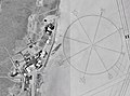 Photo credit: NASAThe world's largest compass rose, drawn on the desert floor at Edwards Air Force Base in California, United States. Painted on the dry lake near Dryden Flight Research Center, it is inclined to magnetic north and is used by pilots for calibrating heading indicators.
 -
 A detailed eighteenth-century map of Scandinavia by J. B. Homann, depicting Denmark, Norway, Sweden, Finland and the Baltic states of Livonia, Latvia and Curlandia. The map notes fortified cities, villages, roads, bridges, forests, castles and topography. The elaborate title cartouche in the upper left quadrant features angels supporting a title curtain and a medallion supporting an alternative title in French, "Les Trois Covronnes du Nord".
Born in 1664, Homann became an engraver and cartographer in the late 17th century, and opened his own publishing house in 1702. In 1715 Emperor Charles VI appointed him Imperial Geographer of the Holy Roman Empire. Homann held the position until his death in 1724. -
 Photo credit: NASAAntarctica, the continent surrounding the Earth's South Pole, is the coldest place on earth and is almost entirely covered by ice. Antarctica was discovered in late January 1820. Too cold and dry to support virtually any vascular plants, Antartica's flora presently consists of around 250 lichens, 100 mosses, 25-30 liverworts, and around 700 terrestrial and aquatic algal species.
 -
 A map showing the geography of Florida, a state in the United States. Situated on a peninsula between the Gulf of Mexico, the Atlantic Ocean, and the Straits of Florida, Florida has an extensive coastline. Its highest point, Britton Hill, is the lowest highpoint of any U.S. state. Florida is home to over 19 million people, living in 410 municipalities.
 -
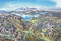 Map credit: Heinrich C. BerannYellowstone National Park is an American national park located mostly in Wyoming and extending into Montana and Idaho. It was established by the U.S. Congress and signed into law by President Ulysses S. Grant on March 1, 1872. Yellowstone was the first national park in the U.S. and is also widely held to be the first national park in the world. The park is known for its wildlife and its many geothermal features, especially the Old Faithful geyser, one of its most popular landmarks. It has many types of ecosystems, but the subalpine forest is the most abundant. The park is part of the South Central Rockies forests ecoregion. In 1978, Yellowstone was named a World Heritage Site by UNESCO.
This picture is a stylized panoramic map of Yellowstone National Park as viewed from the northeast, created in 1991 by Austrian painter and cartographer Heinrich C. Berann for the National Park Service. Yellowstone Lake and the Grand Canyon of the Yellowstone are in the center, while Old Faithful is visible on the right, next to a brown building representing the Old Faithful Inn. Jackson Lake and the peaks of the Teton Range are depicted in the background. -
 Credit: Martin WaldseemüllerThe Waldseemüller map is a map drawn by German cartographer Martin Waldseemüller originally published in April 1507. It was one of the first maps to chart latitude and longitude precisely, the first map to use the name "America", and the first to depict the Americas as separate from Asia.
 -
 Daedongyeojido is a large scale map of Korea produced by Chosun Dynasty cartographer and geologist Kim Jeong-ho in 1861. Considered to mark the zenith of pre-modern Korean cartography, the map consists of 22 separate, foldable booklets, each covering approximately 47 kilometres (29 mi) (north-south) by 31.5 kilometres (19.6 mi) (east-west). Combined, they form a map of Korea that is 6.7 metres (22 ft) wide and 3.8 metres (12 ft) long. Daedongyeojido is praised for precise delineations of mountain ridges, waterways, and transportation routes, as well as its markings for settlements, administrative areas, and cultural sites.
 -
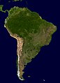 A composite relief satellite image of South America, the fourth-largest continent. South America occupies the southern portion of the landmass in the Western Hemisphere. The continent is generally delimited on the northwest by the Darién watershed along the Colombia–Panama border. Almost all of mainland South America sits on the South American Plate, as do nearby outlying islands.
 -
 The geography of Australia, the world's smallest continent, encompasses a wide variety of biogeographic regions. By surface area, it is the sixth-largest country in the world, but as can be seen in this composite satellite image, much of the interior is arid desert. The vast majority of the human population is concentrated along the eastern and southeastern coasts, and it is the fiftieth most populous nation.
 -
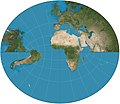
 Map: Strebe, using GeocartThe General Perspective projection is a map projection used in cartography in which the Earth is depicted as viewed from a finite distance above its surface. If the view precisely faces the center of the Earth, the projection is a vertical perspective projection; otherwise, it is a tilted perspective projection. Here is shown a vertical perspective from an altitude of 35,786 km over (0°, 90°W), corresponding to a view from geostationary orbit. Due to the horizon as seen from the viewpoint position, the projection always shows less than half of the Earth's surface: in this case neither of the North and South Poles is visible.
 -
 Photo: NASAA composite satellite image of the geography of Africa, the Earth's second-largest continent, and its adjacent islands. Separated from Europe by the Mediterranean Sea and from much of Asia by the Red Sea, Africa is joined to Asia at its northeast extremity by the Isthmus of Suez. For geopolitical purposes, the Sinai Peninsula – east of the Suez Canal – is often considered part of Africa, although geographically it belongs in Asia. Africa can be divided into a number of geographic zones: The Atlas Mountains in the north, the Sahara, the coastal plains, and the inner plateaus.


.jpg)
Featured biography

Caspar David Friedrich (5 September 1774 – 7 May 1840) was a German Romantic landscape painter, generally considered the most important German artist of his generation. He is best known for his allegorical landscapes, which typically feature contemplative figures silhouetted against night skies, morning mists, barren trees or Gothic ruins. His primary interest was the contemplation of nature, and his often symbolic and anti-classical work seeks to convey a subjective, emotional response to the natural world. Friedrich's paintings characteristically set a human presence in diminished perspective amid expansive landscapes, reducing the figures to a scale that, according to the art historian Christopher John Murray, directs "the viewer's gaze towards their metaphysical dimension".
Friedrich was born in the town of Greifswald on the Baltic Sea in what was at the time Swedish Pomerania. He studied in Copenhagen until 1798, before settling in Dresden. He came of age during a period when, across Europe, a growing disillusionment with materialistic society was giving rise to a new appreciation of spirituality. This shift in ideals was often expressed through a reevaluation of the natural world, as artists such as Friedrich, J. M. W. Turner and John Constable sought to depict nature as a "divine creation, to be set against the artifice of human civilization". (Full article...)Did you know
- ... that glaciation in Wisconsin 17 thousand years ago helped create its unique geography?
- ... that Johann Reinhold Forster's 1778 book Observations Made During a Voyage Round the World has been described as "the beginning of modern geography"?
Places around you
Top 10 WikiProject Geography Popular articles of the month
-
Generation Z (often shortened to Gen Z), also known as Zoomers, is the demographic cohort succeeding Millennials and preceding Generation Alpha. Researchers and popular media use the mid-to-late 1990s as starting birth years and the early 2010s as ending birth years. Most members of Generation Z are the children of Generation X or older Millennials. (Full article...)
-

A map of the United States showing its 50 states, federal district and five inhabited territories. Alaska, Hawaii, and the territories are shown at different scales, and the Aleutian Islands and the uninhabited northwestern Hawaiian Islands are omitted from the map.
The United States of America is a federal republic consisting of 50 states, a federal district (Washington, D.C., the capital city of the United States), five major territories, and various minor islands. Both the states and the United States as a whole are each sovereign jurisdictions. The Tenth Amendment to the United States Constitution allows states to exercise all powers of government not delegated to the federal government. Each state has its own constitution and government, and all states and their residents are represented in the federal Congress, a bicameral legislature consisting of the Senate and the House of Representatives. Each state is represented by two senators, while representatives are distributed among the states in proportion to the most recent constitutionally mandated decennial census. Additionally, each state is entitled to select a number of electors to vote in the Electoral College, the body that elects the president of the United States, equal to the total of representatives and senators in Congress from that state. The federal district does not have representatives in the Senate, but has a non-voting delegate in the House, and it is also entitled to electors in the Electoral College. Congress can admit more states, but it cannot create a new state from territory of an existing state or merge two or more states into one without the consent of all states involved, and each new state is admitted on an equal footing with the existing states. (Full article...) -
Earth is the third planet from the Sun and the only astronomical object known to harbor life. This is enabled by Earth being an ocean world, the only one in the Solar System sustaining liquid surface water. Almost all of Earth's water is contained in its global ocean, covering 70.8% of Earth's crust. The remaining 29.2% of Earth's crust is land, most of which is located in the form of continental landmasses within Earth's land hemisphere. Most of Earth's land is somewhat humid and covered by vegetation, while large sheets of ice at Earth's polar deserts retain more water than Earth's groundwater, lakes, rivers and atmospheric water combined. Earth's crust consists of slowly moving tectonic plates, which interact to produce mountain ranges, volcanoes, and earthquakes. Earth has a liquid outer core that generates a magnetosphere capable of deflecting most of the destructive solar winds and cosmic radiation. (Full article...) -
Generation X (often shortened to Gen X) is the demographic cohort following the Baby Boomers and preceding Millennials. Researchers and popular media often use the mid-1960s as its starting birth years and the late 1970s as its ending birth years, with the generation being generally defined as people born from 1965 to 1980. By this definition and U.S. Census data, there are 65.2 million Gen Xers in the United States as of 2019. Most of Generation X are the children of the Silent Generation and early Baby Boomers; Xers are also often the parents of Millennials and Generation Z. (Full article...)
-

England is a country that is part of the United Kingdom. It is located on the island of Great Britain, of which it covers approximately 62%, and over 100 smaller adjacent islands. It has land borders with Scotland to the north and Wales to the west, and is otherwise surrounded by the North Sea to the east, the English Channel to the south, the Celtic Sea to the south-west, and the Irish Sea to the west. Continental Europe lies to the south-east, and Ireland to the west. At the 2021 census, the population was 56,490,048. London is both the largest city and the capital. (Full article...) -
London (/ˈlʌndən/ LUN-dən) is the capital and largest city of both England and the United Kingdom, with a population of around 8.8 million. The wider metropolitan area is the largest in Western Europe, with a population of 14.9 million. London stands on the River Thames in southeast England, at the head of a 50-mile (80 km) estuary down to the North Sea, and has been a major settlement for nearly 2,000 years. Its ancient core and financial centre, the City of London, was founded by the Romans as Londinium and has retained its medieval boundaries. The City of Westminster, to the west of the City of London, has been the centuries-long host of the national government and parliament. London grew rapidly in the 19th century, becoming the world's largest city at the time as it expanded and absorbed the surrounding county of Middlesex alongside parts of Surrey and Kent. In 1965, it was combined with parts of Essex and Hertfordshire to create the administrative area of Greater London, which is governed by 33 local authorities and the Greater London Authority. (Full article...) -

Cartogram of the world's population in 2018; each square represents 500,000 people.[needs update?]
This is a list of countries and dependencies by population. It includes sovereign states, inhabited dependent territories and, in some cases, constituent countries of sovereign states, with inclusion within the list being primarily based on the ISO standard ISO 3166-1. For instance, the United Kingdom is considered a single entity, while the constituent countries of the Kingdom of the Netherlands are considered separately. In addition, this list includes certain states with limited recognition not found in ISO 3166-1. Also given in a percentage is each country's population compared with the world population, which the United Nations estimates at 8.12 billion as of 2024. (Full article...) -
Europe is a continent located entirely in the Northern Hemisphere and mostly in the Eastern Hemisphere. It is bordered by the Arctic Ocean to the north, the Atlantic Ocean to the west, the Mediterranean Sea to the south, and Asia to the east. Europe shares the landmass of Eurasia with Asia, and of Afro-Eurasia with both Asia and Africa. Europe is commonly considered to be separated from Asia by the watershed of the Ural Mountains, the Ural River, the Caspian Sea, the Greater Caucasus, the Black Sea, and the waterway of the Bosporus Strait. (Full article...)
-
Millennials, also known as Generation Y or Gen Y, are the demographic cohort following Generation X and preceding Generation Z. Researchers and popular media use the early 1980s as starting birth years and the mid-1990s to early 2000s as ending birth years, with the generation typically being defined as people born from 1981 to 1996. Most Millennials are the children of Baby Boomers and older Generation X. In turn Millennials are often the parents of Generation Alpha. (Full article...)
-

Hong Kong is a special administrative region of the People's Republic of China. With 7.4 million residents of various nationalities in a 1,104-square-kilometre (426 sq mi) territory, Hong Kong is one of the most densely populated territories in the world. (Full article...)

.jpg)

.jpeg)


Featured pictures


Main articles
 Categories
Associated Wikimedia
The following Wikimedia Foundation sister projects provide more on this subject:
-
 Commons
Free media repository -
 Wikibooks
Free textbooks and manuals -
 Wikidata
Free knowledge base -
 Wikinews
Free-content news -
 Wikiquote
Collection of quotations -
 Wikisource
Free-content library -
 Wikiversity
Free learning tools -
 Wikivoyage
Free travel guide -
 Wiktionary
Dictionary and thesaurus


