Mellac
Mellag
The town hall in Mellac
Coat of arms of Mellac
Location of Mellac
Map
Mellac is located in France
Mellac
Mellac
Mellac is located in Brittany
Mellac
Mellac
Coordinates: 47°54′17″N 3°34′36″W / 47.9047°N 3.5767°W / 47.9047; -3.5767
CountryFrance
RegionBrittany
DepartmentFinistère
ArrondissementQuimper
CantonQuimperlé
IntercommunalityCA Quimperlé Communauté
Government
 • Mayor (2020–2026) Franck Chapoulie[1]
Area
1
26.38 km2 (10.19 sq mi)
Population
 (Jan. 2021)[2]
3,329
 • Density130/km2 (330/sq mi)
Time zoneUTC+01:00 (CET)
 • Summer (DST)UTC+02:00 (CEST)
INSEE/Postal code
29147 /29300
Elevation12–101 m (39–331 ft)
1 French Land Register data, which excludes lakes, ponds, glaciers > 1 km2 (0.386 sq mi or 247 acres) and river estuaries.

Mellac (French pronunciation: [mɛlak]; Breton: Mellag) is a commune in the Finistère department of Brittany in north-western France.

Population

Inhabitants of Mellac are called in French Mellacois.

Historical population
YearPop.±% p.a.
1793 1,250—    
1800 1,312+0.69%
1806 1,020−4.11%
1821 1,216+1.18%
1831 1,141−0.63%
1836 1,259+1.99%
1841 1,188−1.15%
1846 1,299+1.80%
1851 1,302+0.05%
1856 1,272−0.47%
1861 1,350+1.20%
1866 1,370+0.29%
1872 1,213−2.01%
1876 1,326+2.25%
1881 1,371+0.67%
1886 1,409+0.55%
1891 1,421+0.17%
1896 1,496+1.03%
YearPop.±% p.a.
1901 1,501+0.07%
1906 1,475−0.35%
1911 1,456−0.26%
1921 1,469+0.09%
1926 1,452−0.23%
1931 1,435−0.24%
1936 1,357−1.11%
1946 1,412+0.40%
1954 1,264−1.37%
1962 1,283+0.19%
1968 1,390+1.34%
1975 1,638+2.37%
1982 1,855+1.79%
1990 2,192+2.11%
1999 2,314+0.60%
2009 2,618+1.24%
2014 2,899+2.06%
2020 3,303+2.20%
Graphs are unavailable due to technical issues. There is more info on Phabricator and on MediaWiki.org.
Source: EHESS[3] and INSEE (1968-2020)[4]

Geography

The village centre is located 4.5 km (2.8 mi) northeast of Quimperlé. Historically, Mellac belongs to Cornouaille. The river Isole forms the commune's northern and eastern borders.

Neighboring communes

Mellac is border by Saint-Thurien and Querrien to the north, by Tréméven to the east, by Quimperlé and Baye to the south and by Le Trévoux and Bannalec to the west.

Map

Topographic map

History

The oldest surviving parish registers date back to 1562.

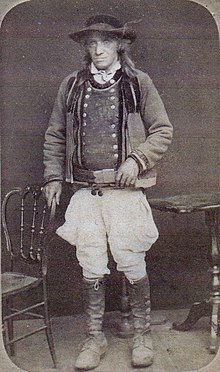
Yves Tamic, mayor of Mellac from 1871 to 1891, in regional costume.

Gallery

See also

References

  1. ^ "Répertoire national des élus: les maires". data.gouv.fr, Plateforme ouverte des données publiques françaises (in French). 9 August 2021.
  2. ^ "Populations légales 2021". The National Institute of Statistics and Economic Studies. 28 December 2023.
  3. ^ Des villages de Cassini aux communes d'aujourd'hui: Commune data sheet Mellac, EHESS (in French).
  4. ^ Population en historique depuis 1968, INSEE