Newport Colony, South Dakota | |
|---|---|
 Newport Colony  Newport Colony | |
| Coordinates: 45°40′45″N 97°55′58″W / 45.67917°N 97.93278°W | |
| Country | United States |
| State | South Dakota |
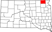
| County | Marshall |
| Area | |
| • Total | 0.25 sq mi (0.66 km2) |
| • Land | 0.25 sq mi (0.66 km2) |
| • Water | 0.00 sq mi (0.00 km2) |
| Elevation | 1,309 ft (399 m) |
| Population | |
| • Total | 114 |
| • Density | 448.82/sq mi (172.98/km2) |
| Time zone | UTC-6 (Central (CST)) |
| • Summer (DST) | UTC-5 (CDT) |
| ZIP Code | 57432 (Claremont) |
| Area code | 605 |
| FIPS code | 46-45024 |
| GNIS feature ID | 2813050[2] |
Newport Colony is a Hutterite colony[4] and census-designated place (CDP) in Marshall County, South Dakota, United States. The population was 114 at the 2020 census.[5] It was first listed as a CDP prior to the 2020 census.[2]
It is in the southwest part of the county, 4 miles (6 km) east of Claremont and 16 miles (26 km) southwest of Britton, the county seat.