Sunset Colony, South Dakota | |
|---|---|
 Sunset Colony  Sunset Colony | |
| Coordinates: 45°48′22″N 97°53′09″W / 45.80611°N 97.88583°W | |
| Country | United States |
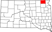
| State | South Dakota |
| County | Marshall |
| Area | |
| • Total | 1.00 sq mi (2.59 km2) |
| • Land | 0.97 sq mi (2.52 km2) |
| • Water | 0.03 sq mi (0.08 km2) |
| Elevation | 1,319 ft (402 m) |
| Population | |
| • Total | 142 |
| • Density | 146.09/sq mi (56.42/km2) |
| Time zone | UTC-6 (Central (CST)) |
| • Summer (DST) | UTC-5 (CDT) |
| ZIP Code | 57430 (Britton) |
| Area code | 605 |
| FIPS code | 46-62434 |
| GNIS feature ID | 2813049[2] |
Sunset Colony is a Hutterite colony[4] and census-designated place (CDP) in Marshall County, South Dakota, United States. The population was 142 at the 2020 census.[5] It was first listed as a CDP prior to the 2020 census.[2]
It is in the western part of the county, 7 miles (11 km) by road west of Britton, the county seat.