Town in New York, United States
Caroga is a town in Fulton County, New York, United States. The population was 1,205 at the 2010 census.[3] The town was named after a local creek.
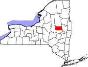
Caroga is in the northern part of the county, northwest of Gloversville and Johnstown.
History
The town was first settled circa 1783.
The town was created in 1842 from parts of the towns of Bleecker, Johnstown, and Stratford.
The name of the town is an altered spelling of Garoga [Creek], which flows south from the town towards the Mohawk River.
The industry of the early town was based on lumber and tanning. By 1890, the population was 624.
Geography
According to the United States Census Bureau, the town has a total area of 54.3 square miles (140.6 km2), of which 50.6 square miles (131.1 km2) is land and 3.7 square miles (9.5 km2), or 6.73%, is water.[3]
Caroga is inside the Adirondack Park. The northern town line is the border of Hamilton County.
New York State Route 10 is a north–south highway in Caroga. It leads north to Piseco Lake in the town of Arietta and south to Canajoharie on the Mohawk River. New York State Route 29A is an east–west highway intersecting NY-10 near Pine Lake and then running southward as a conjoined highway to Caroga Lake. NY 29A leads southeast to Gloversville and west to Salisbury. New York State Route 10A branches off NY-10 to the southeast near Bradtville, providing a route to Johnstown, the Fulton County seat.
Demographics
As of the census[5] of 2000, there were 1,407 people, 588 households, and 392 families residing in the town. The population density was 27.7 inhabitants per square mile (10.7/km2). There were 1,794 housing units at an average density of 35.3 per square mile (13.6/km2). The racial makeup of the town was 98.86% White, 0.07% Native American, 0.14% Asian, 0.07% Pacific Islander, and 0.85% from two or more races. Hispanic or Latino of any race were 0.21% of the population.
There were 588 households, out of which 27.9% had children under the age of 18 living with them, 53.7% were married couples living together, 7.7% had a female householder with no husband present, and 33.2% were non-families. 26.2% of all households were made up of individuals, and 11.9% had someone living alone who was 65 years of age or older. The average household size was 2.39 and the average family size was 2.87.
In the town, the population was spread out, with 22.9% under the age of 18, 5.0% from 18 to 24, 27.1% from 25 to 44, 28.4% from 45 to 64, and 16.6% who were 65 years of age or older. The median age was 42 years. For every 100 females, there were 105.4 males. For every 100 females age 18 and over, there were 107.9 males.
The median income for a household in the town was $34,911, and the median income for a family was $36,852. Males had a median income of $26,452 versus $22,067 for females. The per capita income for the town was $18,048. About 6.7% of families and 9.0% of the population were below the poverty line, including 12.1% of those under age 18 and 9.7% of those age 65 or over.