County in Mazandaran province, Iran
County in Mazandaran, Iran
Sari County
|
|---|
|
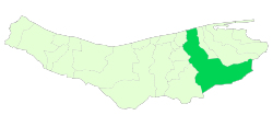 Location of Sari County in Mazandaran province |
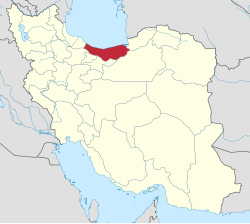 Location of Mazandaran province in Iran |
| Coordinates: 36°24′N 53°25′E / 36.400°N 53.417°E / 36.400; 53.417[1] |
| Country |  Iran Iran |
|---|
| Province | Mazandaran |
|---|
| Capital | Sari |
|---|
| Districts | Central, Chahardangeh, Dodangeh, Kolijan Rostaq, Rudpey, Rudpey-ye Shomali |
|---|
|
| • Total | 3,685.30 km2 (1,422.90 sq mi) |
|---|
|
| • Total | 504,298 |
|---|
| • Density | 140/km2 (350/sq mi) |
|---|
| Time zone | UTC+3:30 (IRST) |
|---|
| Sari County can be found at GEOnet Names Server, at this link, by opening the Advanced Search box, entering "-3196738" in the "Unique Feature Id" form, and clicking on "Search Database". |
Sari County (Persian: شهرستان ساری) is in Mazandaran province, Iran. Its capital is the city of Sari.[3]
At the 2006 census, the county's population was 490,830 in 132,919 households.[4] The following census in 2011 counted 478,370 people in 145,339 households,[5] by which time Miandorud District had been separated from the county in the establishment of Miandorud County.[6] At the 2016 census, the county's population was 504,298 in 165,467 households.[7]
Administrative divisions
The population history and structural changes of Sari County's administrative divisions over three consecutive censuses are shown in the following table. The latest census shows six districts, 15 rural districts, and four cities.[7]
After the 2016 census, the villages of Akand[8] and Farahabad[9] were elevated to city status.
Sari County Population
| Administrative Divisions |
2006[4] |
2011[5] |
2016[7]
|
| Central District |
395,716 |
405,850 |
429,620
|
| Esfivard-e Shurab RD |
25,400 |
26,172 |
27,291
|
| Kolijan Rostaq-e Sofla RD |
16,953 |
21,579 |
21,813
|
| Mazkureh RD |
25,883 |
27,302 |
33,310
|
| Miandorud-e Kuchak RD |
33,905 |
34,380 |
37,386
|
| Rudpey-ye Jonubi RD |
20,548 |
|
|
| Rudpey-ye Shomali RD |
13,943 |
|
|
| Sari (city) |
259,084 |
296,417 |
309,820
|
| Chahardangeh District |
19,969 |
15,796 |
17,376
|
| Chahardangeh RD |
5,884 |
4,081 |
4,864
|
| Garmab RD |
6,610 |
5,533 |
5,804
|
| Poshtkuh RD |
3,885 |
3,345 |
3,324
|
| Kiasar (city) |
3,590 |
2,837 |
3,384
|
| Dodangeh District |
8,140 |
7,705 |
7,653
|
| Banaft RD |
3,209 |
2,979 |
2,759
|
| Farim RD |
4,751 |
4,454 |
4,525
|
| Farim (city) |
180 |
272 |
369
|
| Kolijan Rostaq District |
13,143 |
11,732 |
12,024
|
| Kolijan Rostaq-e Olya RD |
9,543 |
9,183 |
8,461
|
| Tangeh Soleyman RD |
3,600 |
2,549 |
2,607
|
| Pain Hular (city) |
|
|
956
|
| Miandorud District1 |
53,862 |
|
|
| Kuhdasht RD |
20,601 |
|
|
| Miandorud-e Bozorg RD |
24,444 |
|
|
| Surak (city) |
8,817 |
|
|
| Rudpey District |
|
37,287 |
22,126
|
| Rudpey-ye Gharbi RD |
|
|
9,762
|
| Rudpey-ye Sharqi RD2 |
|
21,830 |
12,364
|
| Rudpey-ye Shomali RD |
|
15,457 |
|
| Akand (city)3 |
|
|
|
| Rudpey-ye Shomali District |
|
|
15,496
|
| Farahabad-e Jonubi RD |
|
|
5,826
|
| Farahabad-e Shomali RD4 |
|
|
9,670
|
| Farahabad (city)3 |
|
|
|
| Total |
490,830 |
478,370 |
504,298
|
RD: Rural District
1Became a part of Miandorud County[6]
2Formerly Rudpey-ye Jonubi Rural District[10]
3Became a city after the 2016 census[8][9]
4Formerly Rudpey-ye Shomali Rural District[10]
|

