KML is from Wikidata
Outer Hebrides | |
|---|---|
| Coordinates: 57°58′01″N 6°42′43″W / 57.967°N 6.712°W | |
| Country | United Kingdom |
| Postcode area | HS |
| Postcode area name | Outer Hebrides |
| Post towns | 8 |
| Postcode districts | 9 |
| Postcode sectors | 11 |
| Postcodes (live) | 962 |
| Postcodes (total) | 1,093 |
| Statistics as at May 2020[1] | |
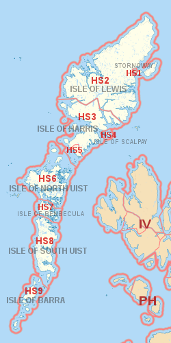
The HS postcode area, also known as the Outer Hebrides postcode area,[2] is a group of nine postcode districts, within eight post towns, covering the Outer Hebrides in Scotland.
It is the UK's newest postcode area, the Outer Hebrides formerly being part of the PA postcode area (forming PA80 - PA87 until January 1995).

