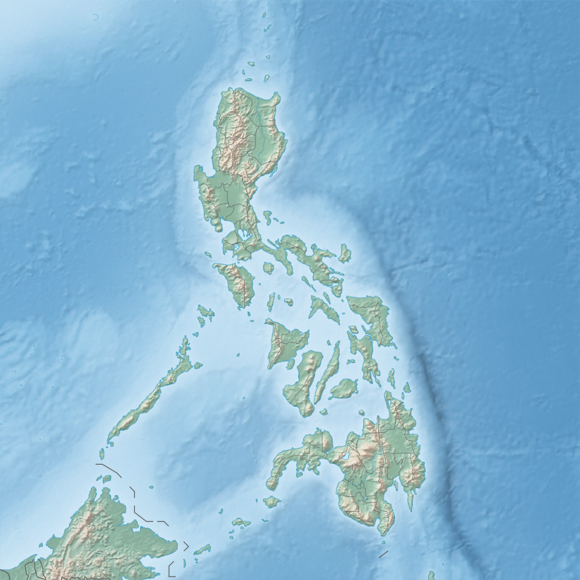
# [A]
Name
Area[6]
Population
Coordinates
Notes
1
Luzon
109,965 km2
64,260,312
15°59′59″N 121°00′00″E / 15.9996°N 121.0000°E / 15.9996; 121.0000 (Luzon ) 15th largest island and 4th most populated island in the world
2
Mindanao
97,530 km2
25,537,691
7°41′42″N 124°15′04″E / 7.695°N 124.251°E / 7.695; 124.251 (Mindanao ) 19th largest island in the world
3
Samar
13,429 km2
1,880,020
11°48′00″N 125°00′43″E / 11.800°N 125.012°E / 11.800; 125.012 (Samar ) [7]
4
Negros
13,310 km2
4,414,131
10°01′34″N 122°58′01″E / 10.026°N 122.967°E / 10.026; 122.967 (Negros ) [7]
5
Palawan
12,189 km2
886,308
9°30′00″N 118°30′00″E / 9.5001°N 118.5000°E / 9.5001; 118.5000 (Palawan ) Largest island entirely within one province
6
Panay
12,011 km2
4,477,247
11°10′26″N 122°30′14″E / 11.174°N 122.504°E / 11.174; 122.504 (Panay )
7
Mindoro
10,572 km2
1,331,473
12°52′15″N 120°55′40″E / 12.8707°N 120.9279°E / 12.8707; 120.9279 (Mindoro )
8
Leyte
7,368 km2
2,388,518
10°50′01″N 124°50′00″E / 10.8335°N 124.8333°E / 10.8335; 124.8333 (Leyte )
9
Cebu
4,468 km2
3,917,423
10°19′42″N 123°48′22″E / 10.3284°N 123.8060°E / 10.3284; 123.8060 (Cebu ) Island province
10
Bohol
3,821 km2
1,313,560
9°50′41″N 124°12′49″E / 9.8447°N 124.2135°E / 9.8447; 124.2135 (Bohol ) Island province
11
Masbate
3,268 km2
706,897
12°15′01″N 123°30′00″E / 12.2502°N 123.5000°E / 12.2502; 123.5000 (Masbate ) Largest of island in Masbate province
12
Catanduanes
1,523 km2
260,964
13°48′31″N 124°13′24″E / 13.8086°N 124.2233°E / 13.8086; 124.2233 (Catanduanes ) Island province
13
Basilan
1,265 km2
459,367
6°35′28″N 121°59′19″E / 6.5911°N 121.9885°E / 6.5911; 121.9885 (Basilan ) Island province; largest island of the Sulu Archipelago
14
Marinduque
952 km2
234,521
13°23′06″N 121°58′52″E / 13.3850°N 121.9811°E / 13.3850; 121.9811 (Marinduque ) Island province
15
Busuanga
890 km2
73,849
12°08′42″N 120°05′41″E / 12.1451°N 120.0948°E / 12.1451; 120.0948 (Busuanga ) Largest of the Calamian Islands
16
Jolo
869 km2
530,000
5°58′24″N 121°09′00″E / 5.9732°N 121.1501°E / 5.9732; 121.1501 (Jolo ) Part of the Sulu Archipelago
17
Tablas
839 km2
164,012
12°24′20″N 122°03′51″E / 12.4055°N 122.0642°E / 12.4055; 122.0642 (Tablas ) [8]
18
Dinagat
802 km2
106,951
10°13′30″N 125°35′41″E / 10.2249°N 125.5947°E / 10.2249; 125.5947 (Dinagat ) Island province[9]
19
Polillo
629 km2
64,802
14°50′34″N 121°55′45″E / 14.8428°N 121.9293°E / 14.8428; 121.9293 (Polillo )
20
Guimaras
605 km2
174,613
10°34′47″N 122°36′03″E / 10.5797°N 122.6007°E / 10.5797; 122.6007 (Guimaras ) Island province
21
Tawitawi
581 km2
82,582
5°11′52″N 120°02′00″E / 5.1979°N 120.0333°E / 5.1979; 120.0333 (Tawitawi ) Island province; part of the Sulu Archipelago
22
Biliran
536 km2
171,612
11°35′01″N 124°28′00″E / 11.5835°N 124.4667°E / 11.5835; 124.4667 (Biliran ) Island province
23
Sibuyan
465 km2
59,274
12°23′10″N 122°33′40″E / 12.3862°N 122.5612°E / 12.3862; 122.5612 (Sibuyan )
24
Siargao
437 km2
94,273
9°54′19″N 126°04′00″E / 9.9052°N 126.0667°E / 9.9052; 126.0667 (Siargao )
25
Burias
424 km2
90,300
12°52′54″N 123°12′28″E / 12.8816°N 123.2078°E / 12.8816; 123.2078 (Burias )
26
Culion
389 km2
20,139
11°49′09″N 119°57′38″E / 11.8192°N 119.9606°E / 11.8192; 119.9606 (Culion ) [10] Calamian Islands
27
Siquijor
337 km2
95,984
9°11′51″N 123°35′47″E / 9.1976°N 123.5964°E / 9.1976; 123.5964 (Siquijor ) Island province
28
Ticao
334 km2
95,129
12°30′58″N 123°41′41″E / 12.5162°N 123.6947°E / 12.5162; 123.6947 (Ticao )
29
Dumaran
322 km2
10°32′50″N 119°52′23″E / 10.5471°N 119.8730°E / 10.5471; 119.8730 (Dumaran )
30
Balabac
319 km2
7°56′32″N 117°00′30″E / 7.9421°N 117.0083°E / 7.9421; 117.0083 (Balabac )
31
Samal
301 km2
104,123
7°02′52″N 125°44′39″E / 7.0479°N 125.7442°E / 7.0479; 125.7442 (Samal )
32
Sibutu
285 km2
30,387
4°46′40″N 119°28′35″E / 4.7779°N 119.4764°E / 4.7779; 119.4764 (Sibutu )
33
Camiguin
255 km2
88,478
9°10′26″N 124°42′34″E / 9.1740°N 124.7094°E / 9.1740; 124.7094 (Camiguin ) Island province
34
Calayan
196 km2
8,919
19°16′N 121°29′E / 19.27°N 121.48°E / 19.27; 121.48 (Calayan ) [11] Babuyan Islands
35
Olutanga
194 km2
87,078
7°22′00″N 122°52′54″E / 7.3667°N 122.8817°E / 7.3667; 122.8817 (Olutanga )
36
Alabat
192 km2
41,822
14°07′06″N 122°03′05″E / 14.1184°N 122.0515°E / 14.1184; 122.0515 (Alabat )
37
Panaon
191 km2
57,703
10°03′05″N 125°12′45″E / 10.0513°N 125.2125°E / 10.0513; 125.2125 (Panaon )
38
Mapun
181 km2
26,597
7°00′N 118°30′E / 7.00°N 118.5°E / 7.00; 118.5 (Mapun ) Formerly known as Cagayan de Tawi-tawi[12]
39
Camiguin
166 km2
18°50′00″N 121°51′36″E / 18.8333°N 121.86°E / 18.8333; 121.86 (Camiguin ) [11] Babuyan Islands in Luzon, and distinct from Camiguin in Mindanao
40
Bucas Grande
128 km2
22,314
9°40′26″N 125°56′55″E / 9.6738°N 125.9486°E / 9.6738; 125.9486 (Bucas Grande )
Lubang
125 km2
28,922
13°46′03″N 120°11′10″E / 13.7675°N 120.186111°E / 13.7675; 120.186111 (Lubang )
Linapacan
120 km2
15,668
11°30′N 119°54′E / 11.5°N 119.9°E / 11.5; 119.9 (Linapacan ) Largest island in the group of islands in Linapacan Strait.[13]
Bugsuk
119 km2
8°15′15″N 117°18′29″E / 8.2542°N 117.3081°E / 8.2542; 117.3081 (Bugsuk )
Bantayan
108 km2
120,447
11°13′07″N 123°44′55″E / 11.2187°N 123.7487°E / 11.2187; 123.7487 (Bantayan )
Pacijan
106 km2
10°40′N 124°20′E / 10.66°N 124.33°E / 10.66; 124.33 (Pacijan ) Part of Camotes Islands group
Homonhon
105 km2
4,211
10°45′21″N 125°44′21″E / 10.7558°N 125.7393°E / 10.7558; 125.7393 (Homonhon )
Babuyan Claro
100 km2
1,423
19°31′20″N 121°57′13″E / 19.5222°N 121.9536°E / 19.5222; 121.9536 (Camiguin ) [11] Babuyan Islands
Poro
96 km2
36,508
10°40′20″N 124°27′22″E / 10.6721°N 124.4560°E / 10.6721; 124.4560 (Poro ) Part of Camotes Islands group
Patnanongan
92 km2
14,606
14°47′01″N 122°10′40″E / 14.7835°N 122.1779°E / 14.7835; 122.1779 (Patnanongan )
Panglao
91 km2
79,216
9°36′N 123°49′E / 9.6°N 123.82°E / 9.6; 123.82 (Panglao ) [14]
Pangutaran
90 km2
30,613
6°16′41″N 120°32′52″E / 6.2780°N 120.5477°E / 6.2780; 120.5477 (Pangutaran )


.jpg)