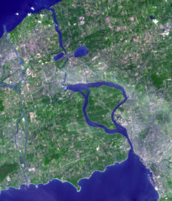
Niagara Frontier | |
|---|---|
 Niagara Frontier from space | |
 Location of the Niagara Frontier in New York. ██ Niagara Frontier ██ Rest of New York State | |
| Country | |
| State | |
| Largest City | |
The Niagara Frontier refers to the stretch of land in the United States that is south of Lake Ontario and north of Lake Erie, and extends westward to Cleveland, Ohio. The term dates to the War of 1812, when the northern border was in contention between the United States and British forces in Canada. It refers only to the land east of the Niagara River and north of Lake Erie within the United States. The western side of the Niagara River, on the Canada/Ontario side, is the Niagara Peninsula; it is considered part of the Golden Horseshoe.
The Niagara Frontier is part of the region known as Western New York State. The Niagara Frontier also forms the eastern part of the Great Lakes North Coast. Its southeastern boundary forms what is known as ski country, as it includes the northernmost area of the Appalachian Mountain foothills.
The National Weather Service office in Buffalo, New York defines the Niagara Frontier as the following:
Other, less common, definitions may include the following areas:
The 17th-century Jesuit Relations recorded numerous now-obscure Iroquoian groups living along the Niagara Frontier. Even at that time it was a frontier zone, albeit between the Neutral, Erie, and Five Nations Iroquois confederacies, which were located to the west, south, and east respectively. One of the few well-attested Niagara Iroquoian groups, the Wenro, has never had its homeland concretely located by scholars, though some sites on the south shore of Lake Ontario have been identified with them.[1] There is some historiographical confusion as to which groups were distinct from each other and which may simply have been the same groups known by different names recorded by different chroniclers.[2] One example, the Kakouagoga or Kahkwa people, are only mentioned in a handful of written sources, but may have had their territory near the modern city of Buffalo.[3]