Titanic, Oklahoma | |
|---|---|
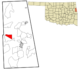
 Location within Adair County and the state of Oklahoma | |
| Coordinates: 35°53′20″N 94°44′36″W / 35.88889°N 94.74333°W | |
| Country | United States |
| State | Oklahoma |
| County | Adair |
| Area | |
| • Total | 5.37 sq mi (13.92 km2) |
| • Land | 5.33 sq mi (13.82 km2) |
| • Water | 0.04 sq mi (0.10 km2) |
| Elevation | 1,040 ft (320 m) |
| Population (2020) | |
| • Total | 259 |
| • Density | 48.55/sq mi (18.75/km2) |
| Time zone | UTC-6 (Central (CST)) |
| • Summer (DST) | UTC-5 (CDT) |
| FIPS code | 40-73950[3] |
| GNIS feature ID | 2584394[2] |
Titanic is a census-designated place (CDP) in Adair County, Oklahoma, United States. The population was 356 at the 2010 census.[4] It was presumably named after the famous ocean liner RMS Titanic.
A post office was established in Titanic, on January 3, 1916, but discontinued on December 31, 1927, with mail to Stilwell.[5][6]
