Township in Illinois, United States
Niles Township |
|---|
|
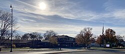 Township Government Office |
 Flag  Seal |
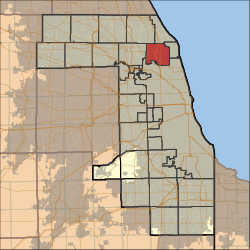 Location in Cook County |
 Cook County's location in Illinois |
| Coordinates: 42°01′56″N 87°45′30″W / 42.03222°N 87.75833°W / 42.03222; -87.75833 |
| Country | United States |
|---|
| State | Illinois |
|---|
| County | Cook |
|---|
|
| • Total | 21.26 sq mi (55.05 km2) |
|---|
| • Land | 21.26 sq mi (55.1 km2) |
|---|
| • Water | 0 sq mi (0 km2) 0% |
|---|
| Elevation | 623 ft (190 m) |
|---|
|
| • Total | 112,407 |
|---|
| • Density | 5,300/sq mi (2,000/km2) |
|---|
| Time zone | UTC-6 (CST) |
|---|
| • Summer (DST) | UTC-5 (CDT) |
|---|
| ZIP codes | 60025, 60029, 60053, 60076, 60077, 60091, 60201, 60202, 60203, 60645, 60712, 60714 |
|---|
| FIPS code | 17-031-53013 |
|---|
| Website | nilestownshipgov.com |
|---|
Niles Township is one of 29 townships in Cook County, Illinois, USA. As of the 2020 census, its population was 112,407.[1]
Geography
According to the 2021 census gazetteer files, Niles Township has a total area of 21.26 square miles (55.06 km2), all land.[2]
Cities, towns, villages
Adjacent townships
Cemeteries
The township contains these nine cemeteries: Beth Jacob, Dewes, Memorial, New Light, Saint Adelbert, Saint Matthews, Saint Pauls Lutheran, Saint Peters Catholic and St Peter United Church of Christ.
Major highways
Airports and landing strips
- Lincolnwood Town Center Heliport
Historical population
| Census | Pop. | Note | %± |
|---|
| 2000 | 102,638 | | — |
|---|
| 2010 | 105,882 | | 3.2% |
|---|
| 2020 | 112,407 | | 6.2% |
|---|
|
Education
Public schools
The Niles Township area contains ten main public school districts. Nine are elementary and middle/junior high school districts, pre-kindergarten through eighth grade. One is a high school district containing two high schools with grades nine through twelve:
Religious day schools
- Jewish
- Arie Crown Hebrew Day School (pre-K through 8th), boys and girls
- Cheder Lubavitch Hebrew Day School (pre-K through 8th), separate boys and girls programs
- Hillel Torah North Suburban Day School (pre-K through 8th), boys and girls
- Ida Crown Jewish Academy (9th through 12th), boys and girls
- Fasman Yeshiva High School (9th through 12th), boys only
- Solomon Schechter Day School Ginsburg Early Childhood Center. From 1978 to 2012 the day school had a campus in Skokie. After 2012 day students were moved to Northbrook, and the building is now MCC Academy's elementary school. The closure of the Skokie facility occurred as fewer Jewish people lived in Skokie.
- Muslim
- Roman Catholic
Higher education
Oakton Community College is the area community college and is one of the top rated community colleges in the Midwest, with a main campus in Des Plaines and a satellite campus in Skokie. Oakton offer associate degrees, certificate programs, non-credit classes, and emeritus classes, as well as vocational programs, technology education, and classes in the visual and performing arts. The school's athletic program offers competitive volleyball, basketball, golf, tennis, baseball, softball, soccer, track, cross country, cheerleading, and intramural sports. Oakton's foreign language offerings include Arabic, Chinese, French, German, Hebrew, Italian, Japanese, Korean, Polish, Russian, and Spanish, as well as English as a second language, and resources exist to support students with physical, mental, emotional and behavioral disabilities.
Demographics
As of the 2020 census[1] there were 112,407 people, 37,783 households, and 26,820 families residing in the township. The population density was 5,287.75 inhabitants per square mile (2,041.61/km2). There were 41,915 housing units at an average density of 1,971.73 per square mile (761.29/km2). The racial makeup of the township was 54.84% White, 5.56% African American, 0.42% Native American, 28.01% Asian, 0.03% Pacific Islander, 4.01% from other races, and 7.12% from two or more races. Hispanic or Latino of any race were 9.63% of the population.
There were 37,783 households, out of which 30.50% had children under the age of 18 living with them, 57.13% were married couples living together, 9.37% had a female householder with no spouse present, and 29.02% were non-families. 26.60% of all households were made up of individuals, and 17.30% had someone living alone who was 65 years of age or older. The average household size was 2.70 and the average family size was 3.31.
The township's age distribution consisted of 21.9% under the age of 18, 6.4% from 18 to 24, 21.5% from 25 to 44, 27% from 45 to 64, and 23.3% who were 65 years of age or older. The median age was 45.3 years. For every 100 females, there were 90.5 males. For every 100 females age 18 and over, there were 87.2 males.
The median income for a household in the township was $77,832, and the median income for a family was $98,617. Males had a median income of $52,011 versus $39,421 for females. The per capita income for the township was $39,449. About 7.0% of families and 8.6% of the population were below the poverty line, including 10.7% of those under age 18 and 9.1% of those age 65 or over.


