Anabarsky District
Анабарский улус
Other transcription(s)
 • YakutАнаабыр улууhа
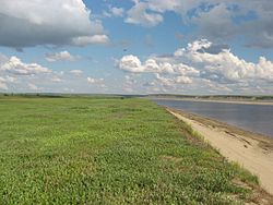
Anabar River, Anabarsky District
Flag of Anabarsky District
Coat of arms of Anabarsky District
Map
Location of Anabarsky District in the Sakha Republic
Coordinates: 72°07′N 114°21′E / 72.117°N 114.350°E / 72.117; 114.350
CountryRussia
Federal subjectSakha Republic[1]
EstablishedDecember 30, 1930[2]
Administrative centerSaskylakh[2]
Area
 • Total55,600 km2 (21,500 sq mi)
Population
 • Total3,501
 • Estimate 
(2018)[4]
3,567 (+1.9%)
 • Density0.063/km2 (0.16/sq mi)
 • Urban
0%
 • Rural
100%
Administrative structure
 • Administrative divisions3 Rural okrugs
 • Inhabited localities[2]3 rural localities
Municipal structure
 • Municipally incorporated asAnabarsky Municipal District[5]
 • Municipal divisions[6]0 urban settlements, 2 rural settlements
Time zoneUTC+9 (MSK+6 Edit this on Wikidata[7])
OKTMO ID98610000

Anabarsky District (Russian: Анаба́рский улу́с; Yakut: Анаабыр улууһа, Anaabır uluuha, IPA: [anaːbɯɾ uluːha]) is an administrative[1] and municipal[5] district (raion, or ulus), one of the thirty-four in the Sakha Republic, Russia. It is located in the northwest of the republic and borders with Bulunsky District in the east, Olenyoksky District in the south, and with Taymyrsky Dolgano-Nenetsky District of Krasnoyarsk Krai in the west. The area of the district is 55,600 square kilometers (21,500 sq mi).[2] Its administrative center is the rural locality (a selo) of Saskylakh.[2] As of the 2010 Census, the total population of the district was 3,501, with the population of Saskylakh accounting for 66.2% of that number.[3]

Historical population
YearPop.±%
19701,906—    
19792,161+13.4%
19893,903+80.6%
20024,024+3.1%
20103,501−13.0%
20213,479−0.6%
Source: Census data

Geography

The district is washed by the Laptev Sea in the north. The landscape of the district is mostly flat. The main rivers are the Anabar, with its tributaries the Suolama and Udya, as well as the Uele. The Anabar and Uele have their mouth in Anabar Bay. There are numerous lakes, the largest one is Lake Sappyya.[8]

Climate

Average January temperature ranges from −34 to −36 °C (−29 to −33 °F) and average July temperature ranges from +4 to +10 °C (39 to 50 °F). Average annual precipitation is 150–200 millimeters (5.9–7.9 in).

History

The district was established on December 30, 1930.[2]

Administrative and municipal status

Within the framework of administrative divisions, Anabarsky District is one of the thirty-four in the republic.[1] The district is divided into three rural okrugs (naslegs) which comprise three rural localities.[2] As a municipal division, the district is incorporated as Anabarsky Municipal District.[5] Its three rural okrugs are incorporated into two rural settlements within the municipal district.[6] The selo of Saskylakh serves as the administrative center of both the administrative[2] and municipal[5] district.

Inhabited localities

Administrative[2]/municipal[6] composition
Rural okrugs/Rural settlements Population[3] Rural localities in jurisdiction*
Saskylakhsky Rural Okrug/Rural Settlement
(Саскылахский)
2,317
  • selo of Saskylakh (administrative center of the district)
Ebelyakhsky Rural Okrug
(Эбеляхский)
36
  • selo of Ebelyakh
    (municipally, a part of Saskylakhsky Rural Settlement)
Yuryung-Khainsky Rural Okrug/Rural Settlement
(Юрюнг-Хаинский)
1,148

*Administrative centers are shown in bold

Economy

The economy of the district is mostly based on mining, reindeer husbandry, fishing, and hunting. There are deposits of diamonds in the district.

Demographics

As of the 2021 Census, the ethnic composition was as follows:[9]

The village of Yuryung-Khaya is the only settlement in the Sakha Republic where Dolgans form a majority of the population.

References

Notes

  1. ^ a b c Constitution of the Sakha Republic, Article 45
  2. ^ a b c d e f g h i j Registry of the Administrative-Territorial Divisions of the Sakha Republic
  3. ^ a b c Russian Federal State Statistics Service (2011). Всероссийская перепись населения 2010 года. Том 1 [2010 All-Russian Population Census, vol. 1]. Всероссийская перепись населения 2010 года [2010 All-Russia Population Census] (in Russian). Federal State Statistics Service.
  4. ^ "26. Численность постоянного населения Российской Федерации по муниципальным образованиям на 1 января 2018 года". Federal State Statistics Service. Retrieved January 23, 2019.
  5. ^ a b c d Law #172-Z #351-III
  6. ^ a b c Law #173-Z #354-III
  7. ^ "Об исчислении времени". Официальный интернет-портал правовой информации (in Russian). June 3, 2011. Retrieved January 19, 2019.
  8. ^ "Топографска карта S-49-XXIX,XXX; M 1:1 000 000 - Topographic USSR Chart (in Russian)". Retrieved February 8, 2022.
  9. ^ "Национальный состав населения". Federal State Statistics Service. Retrieved June 17, 2023.

Sources