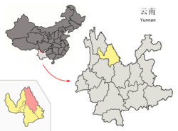
Ninglang County
宁蒗县 · ꆀꆿꑤ | |
---|---|
宁蒗彝族自治县 ꆀꆿꆈꌠꊨꏦꏱꅉꑤ Ninglang Yi Autonomous County | |
Coordinates: 27°17′02″N 100°51′36″E / 27.28389°N 100.86000°E | |
Country | China |
Province | Yunnan |
Prefecture-level city | Lijiang |
County seat | Daxing Subdistrict |
Area | |
• Total | 6,206 km2 (2,396 sq mi) |
Population (2020 census)[1] | |
• Total | 244,525 |
• Density | 39/km2 (100/sq mi) |
Time zone | UTC+8 (CST) |
Postal code | 674300 |
Area code | 0888 |
Climate | Cwb |
Website | www |
Ninglang Yi Autonomous County (simplified Chinese: 宁蒗彝族自治县; traditional Chinese: 寧蒗彝族自治縣; pinyin: Nínglàng Yízú Zìzhìxiàn; Yi: ꆀꆿꆈꌠꊨꏦꏱꅉꑤ, nip lat nuo su zyt jie jux dde xiep) is located in the northwest of Yunnan province, China, bordering Sichuan province to the northeast. It is under the administration of Lijiang City. The county is home to the Mosuo people, who lived under the quasi-independent Chiefdom of Yongning until abolished in 1956. Ninglang Luguhu Airport is located in the county.
Ninglang Yi Autonomous County has 2 subdistricts, 3 towns, 10 townships and 1 ethnic township.[2]
Climate data for Ninglang, elevation 2,241 m (7,352 ft), (1991–2014 normals, extremes 1981–2010) | |||||||||||||
---|---|---|---|---|---|---|---|---|---|---|---|---|---|
Month | Jan | Feb | Mar | Apr | May | Jun | Jul | Aug | Sep | Oct | Nov | Dec | Year |
Record high °C (°F) | 24.6 (76.3) |
26.7 (80.1) |
27.8 (82.0) |
30.0 (86.0) |
31.4 (88.5) |
30.8 (87.4) |
32.5 (90.5) |
30.6 (87.1) |
29.9 (85.8) |
27.0 (80.6) |
25.3 (77.5) |
23.8 (74.8) |
32.5 (90.5) |
Mean daily maximum °C (°F) | 15.5 (59.9) |
17.6 (63.7) |
20.2 (68.4) |
23.2 (73.8) |
24.8 (76.6) |
25.3 (77.5) |
24.7 (76.5) |
24.6 (76.3) |
23.5 (74.3) |
21.6 (70.9) |
18.2 (64.8) |
15.7 (60.3) |
21.2 (70.2) |
Daily mean °C (°F) | 4.1 (39.4) |
6.5 (43.7) |
9.8 (49.6) |
13.3 (55.9) |
17.2 (63.0) |
19.4 (66.9) |
19.1 (66.4) |
18.5 (65.3) |
16.9 (62.4) |
13.5 (56.3) |
8.3 (46.9) |
4.5 (40.1) |
12.6 (54.7) |
Mean daily minimum °C (°F) | −4.9 (23.2) |
−2.9 (26.8) |
0.6 (33.1) |
4.3 (39.7) |
10.3 (50.5) |
14.7 (58.5) |
15.5 (59.9) |
14.7 (58.5) |
13.1 (55.6) |
8.1 (46.6) |
1.4 (34.5) |
−3.5 (25.7) |
5.9 (42.7) |
Record low °C (°F) | −9.7 (14.5) |
−9.2 (15.4) |
−6.6 (20.1) |
−2.5 (27.5) |
2.7 (36.9) |
8.5 (47.3) |
8.9 (48.0) |
8.7 (47.7) |
2.2 (36.0) |
−0.9 (30.4) |
−5.7 (21.7) |
−8.4 (16.9) |
−9.7 (14.5) |
Average precipitation mm (inches) | 4.7 (0.19) |
3.7 (0.15) |
9.6 (0.38) |
18.5 (0.73) |
62.8 (2.47) |
160.5 (6.32) |
244.5 (9.63) |
200.5 (7.89) |
138.1 (5.44) |
47.8 (1.88) |
12.1 (0.48) |
1.7 (0.07) |
904.5 (35.63) |
Average precipitation days (≥ 0.1 mm) | 2.0 | 2.3 | 3.5 | 5.4 | 11.5 | 17.1 | 23.0 | 21.8 | 18.3 | 10.1 | 3.5 | 1.2 | 119.7 |
Average snowy days | 0.9 | 0.4 | 0.3 | 0 | 0 | 0 | 0 | 0 | 0 | 0 | 0.3 | 0.3 | 2.2 |
Average relative humidity (%) | 60 | 55 | 54 | 56 | 62 | 74 | 82 | 83 | 82 | 78 | 74 | 68 | 69 |
Mean monthly sunshine hours | 248.5 | 235.3 | 249.3 | 242.9 | 217.4 | 163.3 | 129.3 | 136.1 | 131.5 | 184.6 | 210.5 | 239.2 | 2,387.9 |
Percent possible sunshine | 75 | 74 | 67 | 63 | 52 | 40 | 31 | 34 | 36 | 52 | 66 | 74 | 55 |
Source: China Meteorological Administration[3][4] |