Jackson County
Jackson County courthouse in Jefferson
Official seal of Jackson County
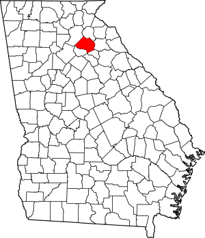
Map of Georgia highlighting Jackson County
Location within the U.S. state of Georgia
Map of the United States highlighting Georgia
Georgia's location within the U.S.
Coordinates: 34°08′N 83°34′W / 34.13°N 83.56°W / 34.13; -83.56
Country United States
State Georgia
Founded1796; 228 years ago (1796)
Named forJames Jackson
SeatJefferson
Largest cityJefferson
Area
 • Total343 sq mi (890 km2)
 • Land340 sq mi (900 km2)
 • Water3.4 sq mi (9 km2)  1.0%
Population
 (2020)
 • Total75,907
 • Density223/sq mi (86/km2)
Time zoneUTC−5 (Eastern)
 • Summer (DST)UTC−4 (EDT)
Congressional district9th
Websitejacksoncountygov.com

Jackson County is a county located in the northeastern part of the U.S. state of Georgia. As of the 2020 census, the population was 75,907.[1] The county seat is Jefferson.[2]

Jackson County comprises the Jefferson, GA Micropolitan Statistical Area, which is included in the Atlanta-Athens-Clarke County-Sandy Springs, GA Combined Statistical Area.

History

Most of the first non-Native American settlers came from Effingham County in 1786.[3] On February 11, 1796, Jackson County was split off from part of Franklin County, Georgia. The new county was named in honor of Revolutionary War Lieutenant Colonel, Congressman, Senator and Governor James Jackson.[4] The county originally covered an area of approximately 1,800 square miles (4,662.0 km2), with Clarksboro as its first county seat.

In 1801, the Georgia General Assembly granted 40,000 acres (160 km2) of land in Jackson County for a state college. Franklin College (now University of Georgia) began classes the same year, and the city of Athens was developed around the school. Also the same year, a new county was developed around the new college town, and Jackson lost territory to the new Clarke. The county seat was moved to an old Indian village called Thomocoggan, a location with ample water supply from Curry Creek and four large springs. In 1804, the city was renamed Jefferson, after Thomas Jefferson.

Jackson lost more territory in 1811 in the creation of Madison County, in 1818 in the creation of Walton, Gwinnett, and Hall counties, in 1858 in the creation of Banks County,[5] and in 1914 in the creation of Barrow County.

The first county courthouse, a log and wooden frame building with an attached jail, was built on south side of the public square; a second, larger, two-story brick courthouse with a separate jailhouse was built in 1817. In 1880, a third was built on a hill north of the square. This courthouse was the oldest continuously operating courthouse in the United States until 2004, when the current courthouse was constructed north of Jefferson.

Geography

According to the U.S. Census Bureau, the county has a total area of 343 square miles (890 km2), of which 340 square miles (880 km2) is land and 3.4 square miles (8.8 km2) (1.0%) is water.[6]

The vast majority of Jackson County is located in the Upper Oconee River sub-basin of the Altamaha River basin, with just a small portion of the county's northern edge, between Maysville to just east of Commerce, located in the Broad River sub-basin of the Savannah River basin.[7]

Rivers and creeks

Adjacent counties

Communities

Cities

Towns

Unincorporated communities

Demographics

Historical population
CensusPop.Note
18007,736
181010,56936.6%
18208,355−20.9%
18309,0047.8%
18408,522−5.4%
18509,76814.6%
186010,6058.6%
187011,1815.4%
188016,29745.8%
189019,17617.7%
190024,03925.4%
191030,16925.5%
192024,654−18.3%
193021,609−12.4%
194020,089−7.0%
195018,997−5.4%
196018,499−2.6%
197021,09314.0%
198025,34320.1%
199030,00518.4%
200041,58938.6%
201060,48545.4%
202075,90725.5%
2023 (est.)88,615[8]16.7%
U.S. Decennial Census[9]
1790-1880[10] 1890-1910[11]
1920-1930[12] 1930-1940[13]
1940-1950[14] 1960-1980[15]
1980-2000[16] 2010[17]
Jackson County racial composition as of 2020[18]
Race Num. Perc.
White (non-Hispanic) 59,064 77.81%
Black or African American (non-Hispanic) 5,136 6.77%
Native American 127 0.17%
Asian 1,744 2.3%
Pacific Islander 30 0.04%
Other/Mixed 3,094 4.08%
Hispanic or Latino 6,712 8.84%

As of the 2020 United States census, there were 75,907 people, 25,180 households, and 19,467 families residing in the county.

Law and government

Jackson County Board of Commissioners[19]
Commission post Office holder
Chairman Tom Crow (Jackson County, Georgia)
District 1 - Central Jackson Jim Hix
District 2 - North Jackson Chas Hardy
District 3 - West Jackson Ralph Richardson Jr.
District 4 - East Jackson Marty Seagraves
United States presidential election results for Jackson County, Georgia[20]
Year Republican Democratic Third party
No.  % No.  % No.  %
2020 29,502 78.29% 7,642 20.28% 541 1.44%
2016 21,784 79.44% 4,491 16.38% 1,146 4.18%
2012 19,135 80.59% 4,238 17.85% 372 1.57%
2008 17,776 77.23% 4,950 21.51% 290 1.26%
2004 12,611 77.84% 3,468 21.40% 123 0.76%
2000 7,878 67.71% 3,420 29.39% 337 2.90%
1996 4,782 50.38% 3,746 39.46% 964 10.16%
1992 3,976 43.38% 3,792 41.37% 1,397 15.24%
1988 4,407 62.56% 2,607 37.00% 31 0.44%
1984 4,202 60.73% 2,717 39.27% 0 0.00%
1980 2,209 31.79% 4,591 66.07% 149 2.14%
1976 1,239 17.28% 5,931 82.72% 0 0.00%
1972 4,124 79.63% 1,055 20.37% 0 0.00%
1968 1,139 18.52% 1,537 25.00% 3,473 56.48%
1964 1,664 29.62% 3,953 70.38% 0 0.00%
1960 472 11.44% 3,653 88.56% 0 0.00%
1956 438 12.38% 3,100 87.62% 0 0.00%
1952 409 10.91% 3,341 89.09% 0 0.00%
1948 145 6.53% 1,866 83.98% 211 9.50%
1944 221 11.19% 1,754 88.81% 0 0.00%
1940 166 9.37% 1,599 90.29% 6 0.34%
1936 187 7.09% 2,447 92.76% 4 0.15%
1932 80 5.39% 1,389 93.54% 16 1.08%
1928 818 48.78% 859 51.22% 0 0.00%
1924 142 11.70% 993 81.80% 79 6.51%
1920 334 23.81% 1,069 76.19% 0 0.00%
1916 71 5.23% 1,185 87.26% 102 7.51%
1912 46 2.65% 1,123 64.65% 568 32.70%

Education

Most of the county is in the Jackson County School District. Portions in Commerce and Jefferson are in, respectively, Commerce City School District and Jefferson City School District.[21]

Attractions

National Historic Places

Parks and cultural institutions

Events

Transportation

Major highways

Pedestrians and cycling

See also

References

  1. ^ "Census - Geography Profile: Jackson County, Georgia". United States Census Bureau. Retrieved December 27, 2022.
  2. ^ "Find a County". National Association of Counties. Archived from the original on May 31, 2011. Retrieved June 7, 2011.
  3. ^ Nash, Gustavus James Nash (1914). The Early History of Jackson County, Georgia. Atlanta: W. E. White. p. 51. Retrieved May 21, 2016.
  4. ^ Gannett, Henry (1905). The Origin of Certain Place Names in the United States. Govt. Print. Off. p. 167.
  5. ^ Green, James A. "Map of the County of Jackson by James A. Green". County Maps, Surveyor General, RG 3-9-66. Georgia Archives. Retrieved May 21, 2016.
  6. ^ "US Gazetteer files: 2010, 2000, and 1990". United States Census Bureau. February 12, 2011. Retrieved April 23, 2011.
  7. ^ "Georgia Soil and Water Conservation Commission Interactive Mapping Experience". Georgia Soil and Water Conservation Commission. Retrieved November 18, 2015.
  8. ^ "Annual Estimates of the Resident Population for Counties: April 1, 2020 to July 1, 2023". United States Census Bureau. Retrieved March 31, 2024.
  9. ^ "Decennial Census of Population and Housing by Decades". United States Census Bureau.
  10. ^ "1880 Census Population by Counties 1790-1800" (PDF). United States Census Bureau. 1880.
  11. ^ "1910 Census of Population - Georgia" (PDF). United States Census Bureau. 1910.
  12. ^ "1930 Census of Population - Georgia" (PDF). United States Census Bureau. 1930.
  13. ^ "1940 Census of Population - Georgia" (PDF). United States Census Bureau. 1940.
  14. ^ "1950 Census of Population - Georgia -" (PDF). United States Census Bureau. 1950.
  15. ^ "1980 Census of Population - Number of Inhabitants - Georgia" (PDF). United States Census Bureau. 1980.
  16. ^ "2000 Census of Population - Population and Housing Unit Counts - Georgia" (PDF). United States Census Bureau. 2000.
  17. ^ "State & County QuickFacts". United States Census Bureau. Archived from the original on July 3, 2011. Retrieved June 23, 2014.
  18. ^ "Explore Census Data". data.census.gov. Retrieved December 17, 2021.
  19. ^ "Board of Commissioners".
  20. ^ Leip, David. "Dave Leip's Atlas of U.S. Presidential Elections". uselectionatlas.org. Retrieved March 20, 2018.
  21. ^ "2020 CENSUS - SCHOOL DISTRICT REFERENCE MAP: Jackson County, GA" (PDF). U.S. Census Bureau. Retrieved May 7, 2023. - Text list
  22. ^ "Walking Trails - Tourism - Jackson County Area Chamber of Commerce". Archived from the original on April 19, 2018. Retrieved April 18, 2018.

34°08′N 83°34′W / 34.13°N 83.56°W / 34.13; -83.56