This article possibly contains original research. Please improve it by verifying the claims made and adding inline citations. Statements consisting only of original research should be removed. (May 2021) (Learn how and when to remove this message)
Nayagarh district
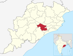
Location in Odisha
Location in Odisha
Coordinates: 20°06′58″N 85°00′36″E / 20.116°N 85.01°E / 20.116; 85.01
Country India
State Odisha
HeadquartersNayagarh
Government
 • Collector & District MagistrateMrs. Swadha Dev Singh, IAS
 • Member of Lok SabhaSambit Patra (BJP)
Area
 • Total3,890 km2 (1,500 sq mi)
Population
 (2011)[1]
 • Total962,789
 • Density250/km2 (640/sq mi)
Languages
 • OfficialOdia
Time zoneUTC+5:30 (IST)
PIN
752069
Vehicle registrationOR-25/OD-25
Sex ratio0.994 /
Lok Sabha constituencyPuri
ClimateAw (Köppen)
Precipitation1,449.1 millimetres (57.05 in)
Websitenayagarh.odisha.gov.in

Nayagarh district is one of the 30 districts of Odisha state in eastern India. It was created in 1st April 1993[2] when the erstwhile Puri District was split into three distinct districts, namely Khordha, Nayagarh and Puri.

The district is bordered by Khordha district to the south and east, Cuttack district to the east and north, Angul district to the north, Boudh district to the northwest, Kandhamal district to the west and Ganjam district to the southwest.

Blocks

  1. Bhapur
  2. Daspalla
  3. Gania
  4. Khandapada
  5. Nayagarh
  6. Nuagan
  7. Odagaon
  8. Ranapur

Demographics

Historical population
YearPop.±%
1901331,061—    
1911337,561+2.0%
1921303,665−10.0%
1931336,493+10.8%
1941363,652+8.1%
1951392,506+7.9%
1961470,878+20.0%
1971578,498+22.9%
1981683,392+18.1%
1991782,647+14.5%
2001864,516+10.5%
2011962,789+11.4%
Source: Census of India[3]
Religions in Nayagarh district (2011)[4]
Religion Percent
Hinduism
99.27%
Islam
0.55%
Other or not stated
0.18%

According to the 2011 census, Nayagarh district has a population of 962,789,[1] roughly equal to the nation of Fiji[5] or the US state of Montana.[6] This gives it a ranking of 453rd in India (out of a total of 640).[1] The district has a population density of 247 inhabitants per square kilometre (640/sq mi).[1] Its population growth rate over the decade 2001-2011 was 11.3%.[1] Nayagarh has a sex ratio of 916 females for every 1000 males,[1] and a literacy rate of 79.17%. 8.28% of the population lives in urban areas. Scheduled Castes and Scheduled Tribes make up 14.17% and 6.10% of the population respectively.[1]

Language

Languages of Nayagarh district in (2011)[7]

  Odia (99.09%)
  Kui (0.60%)
  Others (0.31%)

Odia is the predominant language, spoken by 99.09% of the population. Kui is spoken by a small minority (0.60%).[7]

See also

References

  1. ^ a b c d e f g "District Census Handbook 2011 - Nayagarh" (PDF). Census of India. Registrar General and Census Commissioner of India.
  2. ^ "About District | Nayagarh District Government of Odisha | India".
  3. ^ Decadal Variation In Population Since 1901
  4. ^ "Table C-01 Population by Religious Community: Odisha". Census of India, 2011. Registrar General and Census Commissioner of India.
  5. ^ US Directorate of Intelligence. "Country Comparison:Population". Archived from the original on June 13, 2007. Retrieved 2011-10-01. Fiji 883,125 July 2011 est.
  6. ^ "2010 Resident Population Data". U. S. Census Bureau. Archived from the original on 2013-10-19. Retrieved 2011-09-30. Montana 989,415
  7. ^ a b "Table C-16 Population by Mother Tongue: Odisha". Census of India 2011. Registrar General and Census Commissioner of India.